Seattle’s home-grown railroad, the Seattle, Lake Shore & Eastern Railway, began running in 1887. Railway stations and post offices were opened as the train passed through population centers, and these gave names to the neighborhoods. This blog article will trace the rise and fall of neighborhood names near Fremont in Seattle.
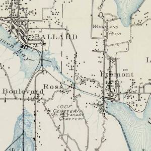
McKees Correct Road Map of 1894, courtesy of Seattle Public Library.
Just north of Seattle’s Queen Anne hill, the Ross family had land claims on both sides of a stream called The Outlet, which flowed from Lake Union westward out to Puget Sound. The Ross family gave permission for the new railroad to cross their property, and the railroad planners named a station in their honor. This caused the area to acquire “Ross” as a place name.
Ross was located to the west of Fremont, bordered by 3rd Ave West, and it included land on the south side of today’s ship canal.
The earliest listings of “Seattle Seminary” (today’s Seattle Pacific University) in the City Directory of the 1890s gave its location as “Ross.” This also had to do with an actual post office for Ross, so that people could list it as their address. Starting in 1887 as the Seattle. Lake Shore & Eastern Railroad was being built and was advancing through these communities, rail stops and postal stations were established along the line. Over time, some of these names “stuck” and some, like Ross, faded away.