

Approval celebration, part of the property acquisition process, on March 17, 1974. Mayor Charles Royer at center, City Councilwoman Jeanette Williams at right. Photo courtesy of the Seattle Municipal Archives #170708.
One of Wedgwood’s proudest claims-to-fame is as the birthplace of the Burke-Gilman Trail which officially opened on August 19, 1978.
This wonderful urban amenity links northeast Seattle neighborhoods with nature. As a transportation resource the Trail helps to reduce car traffic by making it possible for people to walk or bike to work. On the level of health and enjoyment of the outdoors, the availability of a walking trail in a beautiful natural setting is one of the treasures of northeast Seattle.
The creation of the Burke-Gilman Trail was spearheaded by a group of Wedgwood neighbors in the 1970s, who worked together and got through the process of steps for the City to acquire the old railroad route. The Trail, which is now for walking and biking, began as a railroad route back in the 1880s when Seattle was desperate for rail transportation of merchandise and raw materials.
Seattle’s struggle to acquire rail lines
Seattle of the 1870s was a remote, hard-to-reach region hampered by the lack of roads or rail transportation. At first Seattle relied upon water transport to receive merchandise brought by ships from San Francisco and send raw materials out, primarily timber. As trees were cut down and the available timber was farther away from the shores of Puget Sound, it became more and more essential to have rail transport. The need was sharpened by the discovery of coal in eastern King County in areas such as Gilman (Issaquah) and Newcastle (Renton area). Coal was the fuel of choice for local industries prior to the use of electricity, and getting the coal into Seattle was a very laborious task without a continuous rail line.

Judge Thomas Burke (1849-1925) Image courtesy of MOHAI #1559
Beginning in the 1870s city leaders lobbied to get railway corporations to build a terminus, but Seattle was consistently bypassed in favor of Tacoma. On May Day 1874 nearly the whole population of Seattle turned out to begin digging a roadbed for Seattle’s own railroad, without any help from big corporations. It was originally planned that the line would cross the Cascade Mountains at Snoqualmie Pass and join with another railroad at Walla Walla, thus the name “Seattle & Walla Walla Railroad.”
Although Seattle’s do-it-yourself railroad never got extended farther than the coal fields at Renton, during the campaign the term “Seattle Spirit” was coined, which became a rallying cry whenever civic pride needed to be stirred up. It took three years to finish the line to Renton (about sixteen miles) but it was well worth it for the ability to bring out coal from the mines at Newcastle.
Moreover, the 1874 railroad campaign had long-running public relations value. Seattle had been snubbed by major rail lines but had refused to give up. This story of Seattle Spirit got national attention and enhanced Seattle’s reputation as an up-and-coming place, which would prove valuable during the next big push for a locally-controlled railroad in the 1880s.
The Seattle, Lake Shore & Eastern Railroad

Daniel Hunt Gilman in 1890, one of the early Seattleites who worked to bring in rail transportation.
On April 15, 1885, twelve Seattle citizens incorporated the Seattle, Lake Shore & Eastern Railroad Company. Because of Seattle’s excellent reputation as an up-and-coming place, SLS&E representatives Daniel Gilman and Judge Thomas Burke were able to line up one million dollars from investors in the eastern USA for the building of Seattle’s own railroad.
The money invested in the line was spent largely in Seattle, causing an economic boom. Jobs were created in the railroad construction, and the anticipation of more economic opportunity caused businesses such as sawmills and stores to spring up along the line of the new railroad.
From downtown Seattle the SLS&E Railroad followed a course north to Ballard. Burke & Gilman were members of the investment group who created the planned community of Ballard, and they had been working for years to acquire land along the right-of-way for their proposed railroad. From Ballard, the railroad proceeded eastward through what is now Fremont.
As of 1887 the Fremont neighborhood had not yet been created. To obtain right-of-way through the property, Burke & Gilman had purchased land from the estates of original Fremont-area homesteaders John Ross and William Strickler. Burke was also a member of the consortium of investors who wanted to create a ship canal. Though the plans for the ship canal were not fully realized for many more decades, with amazing foresight Burke had focused on the site which is the ship canal of today, and that is why he wanted the railroad to run alongside it — for industrial access.

Charles Baker, sitting on Snoqualmie Falls and holding the electric lines of a streetcar.
As they continued extending the railroad course, the SLS&E founders employed a young surveyor, Charles H. Baker. Baker made speculative land investment purchases in the Fremont area and even in Wedgwood in northeast Seattle, as he believed that the city of Seattle would continue to expand and that rail and streetcar lines would be extended throughout.
From Fremont the SLS&E Railroad ran eastward along what is now the Ship Canal. Even though the Canal would not be built for another thirty years, the planners of the SLS&E Railroad followed the natural lines of the terrain across the north end of Lake Union where they thought that a canal would eventually be built.
The railroad line went through what is now the University of Washington campus, then to the sawmill town of Yesler (Laurelhurst). Beginning in northeast Seattle at what is now Hawthorne Hills, the rail line began a long curving northward turn until it reached the shore of Lake Washington. There were many sawmills close to the lake shore, which could then start loading products onto the rail line. By 1887 the line had been built out around the north end of Lake Washington through Bothell and the line reached Gilman (Issaquah) in March of 1888.
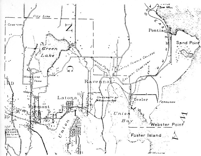
McKee’s Correct Road Map of Seattle and Vicinity, 1894, courtesy of the Seattle Room, Seattle Public Library. The snaking line of the SLS&E Railroad is shown through the communities of Fremont, Latona (Wallingford), Ravenna, Yesler (Laurelhurst) and north past Sand Point. Black dots indicate population clusters. Calvary Cemetery, established 1889, is a point of reference at the corner of NE 55th Street and 35th Ave NE. The Keith Station (Hawthorne Hills) is marked at NE 55th Street and 40th Ave NE on the railroad line.
Communities and businesses are established alongside the rail line

Full-page ad for the Seattle, Lake Shore & Eastern Railroad, page 13 of the 1894-1895 Seattle City Directory.
Judge Thomas Burke took advantage of the railroad boom which he had helped to create, by establishing his own businesses along the line. With co-investors Morgan Carkeek and Corliss P. Stone, the three men acquired property in Pontiac, on what is now Sand Point Way NE at about NE 70th Street. The Pontiac Brick and Tile Company incorporated on January 2, 1889 and the timing couldn’t have been better: just five months later Seattle’s Great Fire of June 6, 1889, created a huge demand for brick to rebuild the city’s downtown core.
It is interesting to note that the site of the Pontiac Brick and Tile Company, which closed in 1914, was later designated to become Carkeek Park, but the property was taken in 1920-1926 for the new Naval Air Station on Sand Point Way NE. King County then compensated by transferring Carkeek Park to Piper’s Creek on Puget Sound.
The photo below is of a page from a “tourist book” written in 1891. It lists the stations of the Seattle, Lake Shore & Eastern Railroad beginning from downtown, northward to Ballard, eastward through Ross and Fremont over to Lake Washington, where the line turned northward and ran along the shoreline.
Other articles here on this blog explore some of the old place names. Later real estate developments often renamed places, such as Keith which is present-day Hawthorne Hills and Yesler Junction which was renamed Laurelhurst. Some places, such as Edgewater and Latona, had their own postal stop/rail stop in the 1890s. Both of these were originally plat names just east of Fremont on the north shore of Lake Union. When the post offices at Edgewater and Latona closed, the names passed out of popular usage and were absorbed into Wallingford. Ravenna got a postal stop on the SLS&E in January, 1890, and that name for the neighborhood has endured to the present time.

A tourism book of the year 1891 gave this list of the rail stops on the Seattle, Lake Shore & Eastern Railroad. See source list at the end of this article for the book reference.
From Rail to Trail
The SLS&E Railroad was taken over by the Great Northern in 1893. Railroad use began to decline in the 1960s. The Great Northern, Northern Pacific, and Burlington lines were merged in 1970 to become Burlington Northern Railroad.
In 1971 Burlington Northern applied to abandon the line which by then was used for little but to bring fuel to the steam plant at the University of Washington. Less than one hundred years after Seattleites turned out with pickaxes to dig a roadbed for their own rail line, the railroad era seemed to be coming to an end as the Burlington Northern prepared to close down service. The railroad era might have ended without recognition if it had not been for an innovative and determined group of Wedgwoodians.

Train trestle crossing over 35th Ave NE near University Village in northeast Seattle. The original rail line is now the Burke-Gilman Trail.
In June of 1970 Irv and Estell Berteig were new in Wedgwood and they were invited to a get-to-know-your-neighbors gathering. Several young couples met, enjoyed one another’s company and agreed to meet again to view and discuss a special series of programs on Channel 9.
While getting acquainted the group began to speculate about what would happen to the railroad tracks and the adjacent land, called the “right-of-way” which passed close by their Wedgwood homes, when the Burlington Northern ceased operations.
Estell had recently talked with a friend from a suburb east of Seattle, who was trying to create a bike trail along the Sammamish River, and who remarked that the abandoned Burlington Northern line “would make a great trail.” Estell and her Wedgwood neighbors came up with the idea of converting the Burlington Northern railroad line into a walking trail, coining the phrase “Rail to Trail.” By November 1970 the Trail Committee was organized with Wedgwood resident Jim Todd as chairman and 36 active members working on the project, campaigning for public ownership of the railway land.
The work of the Trail Committee in 1970 to 1978
Each Trail Committee member was charged with different responsibilities, and to Estell Berteig fell the task of researching the history of the railroad and the property records pertaining to it. Some people believed that when the Burlington Northern Railroad line closed down, the land would legally revert to private ownership so that adjacent homeowners could add the right-of-way to their property. If that was true, it would eliminate the possibility of a public walking trail.

Original King County property transactions in hand-written ledgers kept at the Puget Sound Regional Archives.
Estell’s search led her to the King County property records, where a skeptical clerk told her she would have to look at the original property ledgers of the 1880s, which were hand-written and had no index. Estell insisted that she wanted to try and so, carrying her baby and dragging a stroller and diaper bag behind her, she descended the steps to the basement storage room where the ledgers were kept.
Since Estell did not know the name of the original railroad whose records she was looking for, the clerk tried once again to dissuade her. But Estell pulled out one of the heavy ledgers and it fell open to the page on which was written “Seattle, Lake Shore & Eastern Railroad!”

Seattle Lake Shore & Eastern Railroad opening, 1887. Image 2002.3.936, Museum of History & Industry, photo by Asahel Curtis.
Reading through the records of the SLS&E, Estell saw that there were no reversionary clauses which would allow the railroad right-of-way to revert to private property owners. Rather, there was the repeated phrase, “for the good of the community.” In the 1880s the original property owners along the rail line had sold or in some cases donated the right-of-way to their property, with the understanding that it was to be used for the advancement of Seattle’s best interests.
On this premise, then, Estell and the Trail Committee members were able to make a case for the railroad tracks and right-of-way to continue to be publicly owned. This was an important legal foundation when dealing with Burlington Northern and the Interstate Commerce Commission which would decide what was to be done with the land.
Naming the project:
As she read through the history and property records Estell was struck by the repeated mention of the names Thomas Burke and Daniel Gilman, the two men who spearheaded the organizing of the SLS&E Railroad and who successfully obtained backing from East Coast financiers. In honor of their outstanding Seattle Spirit of the 1880s, Wedgwood’s trail advocates of the 1970s incorporated as the Burke-Gilman Trail Committee.
Members of the Trail Committee contacted Burlington Northern about acquiring the right-of-way for a hiking and biking trail. A lot of research was involved, including maps and photos, and the committee wrote letters with the reasons why the Burlington Northern land should become available to public use, like a park. The Trail Committee contacted civic, cycling and environmental groups to solicit support, and contacted government officials.
The Burlington Northern Railroad wanted to sell the land and their petition to the Interstate Commerce Commission (ICC) was successful at first. Seattle Mayor Wes Uhlman was in favor of the trail and he, along with the Trail Committee and six other groups, was able to get the ICC to reconsider, reversing the original decision. The ICC decided in favor of public ownership of the railroad right-of-way.

Rally for the Trail on September 12, 1971. Image 1986.5.55062.2, Museum of History & Industry. Photo by Tom Barlet of the PI.
On September 12, 1971 the Trail Committee held a hike-in and rally at Matthews Beach for the trail plan. Twenty-five organizations and over 2,000 participants came to the rally, most hiking in along the rail line.
Over the course of the trail effort more than 1,600 people signed petitions supporting the plan and asking Burlington Northern to donate the land. In addition to Mayor Uhlman, King County Executive John Spellman (a View Ridge resident) and Washington State Representative Paul Kraabel (a Wedgwood resident) gave support.
The Burke-Gilman Trail opens in 1978
The original twelve miles of the trail was dedicated on August 19, 1978. Since then there have been extensions and the Burke-Gilman Trail now meets the Sammamish River Trail at Bothell Landing and continues on out to Redmond.

The Burke-Gilman Trail passes by the Metropolitan Market where picnic tables are conveniently nearby.
The Burke-Gilman Trail is now considered such an amenity that real estate advertisements mention it if near to a house offered for sale. Businesses such as Metropolitan Market on NE 55th Street have nurtured their connection to the Trail by setting up picnic tables alongside. It is common to see Trail users step into the Metropolitan Market to get something to eat or drink due to the friendly welcome.
In most recent years Children’s Hospital at 4800 Sand Point Way NE has sought better connections from the Trail to their site and the hospital has encouraged their employees to travel to work via bicycle. The Burke-Gilman Trail has been described as Seattle’s longest trail and skinniest park.
Sources:

In the Puget Sound Regional Archives, the original property records of King County are stored in temperature-controlled vaults.
Property records: the original property ledgers of King County are no longer kept in a basement! The ledgers are now kept in temperature-controlled storage vaults at the Puget Sound Regional Archives (a branch of the state archives system) which is in a building on the campus of Bellevue University.
Friends of the Burke-Gilman at Sand Point (on Facebook) and www.burkegilmanvolunteers.org
Atlantis Arisen; Or, Talks of A Tourist about Oregon and Washington, by Frances Fuller Victor, 1891. Seattle Room, Seattle Public Library, R917.9V665A. Page 309 of this book gives a list of the rail stops along the SLS&E Railroad.
He Built Seattle: A Biography of Judge Thomas Burke, by Robert C. Nesbit, 1961. This excellent source includes an explanation of how the SLS&E was founded and financed, in the context of the railroad era in Seattle. The Seattle Public Library no longer has any circulating copies of this book; copies are on reserve for use at the library only.
 Orphan Road: The Railroad Comes to Seattle 1853-1911, by Kurt E. Armbruster, revised edition 2016. Chapter Nine: Burke, Gilman and the Seattle, Lake Shore & Eastern Railroad, pages 103-119.
Seattle in the 1880s, by David Buerge. The Historical Society of Seattle and King County, 1986.
HistoryLink essays: #149 and #5412 about the difficulty of getting coal out to market without a railroad; #1735 SLS&E Railroad is incorporated; #2487 Sand Point history; #7049 Burke-Gilman Trail; #10221 the Montlake Cut; the interactions of rail and water transportation of raw materials.
Interviews: In the 1990s I (Valarie) interviewed some members of the original Burke-Gilman Trail Committee who were residents of the Wedgwood neighborhood. This blog post is expanded from an earlier article I wrote, which was published in 1999 in a Wedgwood community newsletter.
Here is a recorded presentation in 2018, on the Seattle Channel, from the original organizers telling the History of the Burke Gilman Trail.
History of the nation-wide Rails to Trails Movement.
Public Broadcasting film “From Rails to Trails.”
Northwest Railways Museum. Article about the SLS&E Railway.
Park history files: the City of Seattle Parks Department has an alphabetical list of the Don Sherwood compilation of park histories. On the right side of the index page is a column explaining who Don Sherwood was and how he came to work on the park histories. His work was all hand-written and you will find the document in the index under Burke-Gilman Trail.
“People Power Created the Burke-Gilman Trail,” article in the My Northwest site.
City of Seattle Department of Transportation Burke-Gilman Trail Map.
Street names: There are some streets in Seattle named for investors in the Seattle, Lake Shore & Eastern Railroad. The Writes of Way blog has explored some of these in a plat filed by Daniel Gilman, one of the railroad organizers. Some of the names are Armour, Commodore, and Jameson. Thorndyke Avenue, also in the plat, was the maiden name of Gilman’s wife.
For more info: another article here on my blog, tells of the personal histories of Judge Thomas Burke and Daniel Gilman, and their influence on the development of Seattle.
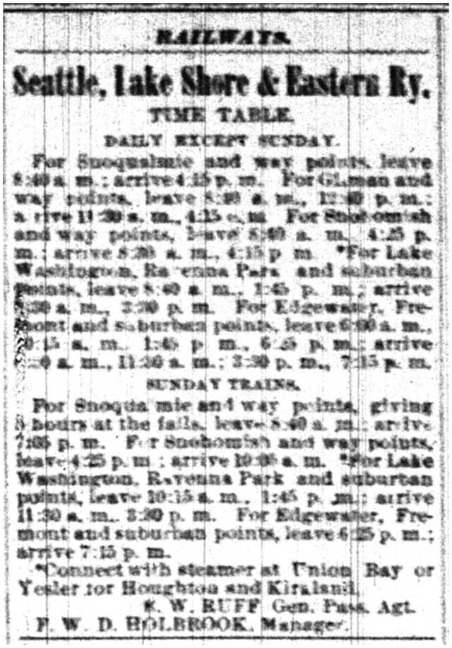
The Seattle, Lake Shore & Eastern Railroad listed their schedule in the Daily Intelligencer newspaper, July 20, 1889.

Well, thank you, Wedgwood, for the Burke-Gilman trail!
I had not know this story until this post. Thank you, Valarie, for the continuing research.
What a terrific piece – thanks Valarie. I’ve been riding the BG for years; good to know how it all started. Passing it on to all my cycling friends!
When I was little, there was a “Santa Special” train that used what is now the B-G trail.
Antique train buffs were among those who wanted to keep the rail line as it was. Ultimately the conversion to a walking trail won out partly due to the economic costs, but mainly because of overwhelming public support for a trail. The B-G Trail movement benefited from the new awareness of the environment — the first Earth Day was celebrated in 1970.
Hi Valarie,
This is really interesting! I am so glad that a handful of determined people pursued this. I have enjoyed biking on the Burke-Gilman, but never knew who to be grateful to for this wonderful gift.
Reblogged this on 10000 Miles of Experiences, Adventures and Thoughts and commented:
I ride this trail multiple times a week, it starts or ends many of my routes, but until now, I did not know how it came to be!
Thanks for reaching out to me and sharing the link to this! I ride the trail multiple times a week and no idea how it was started! I reblogged this on my page.
It is AMAZING that however many times I read your blog, there are new items to discover. I lived in a house on 58th Ave NE that backed on what is now the trail between 1969 and 1972. At that time, the rails were still there and we’d sometimes walk along them to go to the View Ridge Swim Club.