How does the history and development of Wedgwood compare to that of other neighborhoods in Seattle?

The Burke-Gilman Trail is the line of a former railroad and is parallel to the ship canal in Fremont.
Fremont was the site of some of the earliest land claims in Seattle in the 1850s, but it was not populated until developers bought the land in 1888. Fremont had this date as a definite start-point as a community with streets laid out. Its early development was planned by its land investors.
Many aspects of Fremont today, such as its street system and its hub for transportation, can be attributed to the strong period of development in the 1880s. Fremont’s early developers were also invested in the streetcar system and they brought this convenience to Fremont, as well.
Active Seattleite Henry Yesler was a member of the Lake Washington Improvement Company and in 1883 he bought some of William Strickler’s former homestead claim in Fremont for a place to create a canal at the northwest corner of Lake Union. That same year, Judge Thomas Burke bought some of the (future) Fremont land for the right-of-way of the Seattle, Lake Shore & Eastern Railroad. The railroad route has come down to us today as the Burke-Gilman Trail.

The Wedgwood Ale House at 8515 35th Ave NE is in Wedgwood’s earliest business block of the 1920s.
In contrast to Fremont, Wedgwood is a neighborhood which slept quietly until well after the year 1900, with no roads, railroads or other through-routes such as canals. Property records show ownership of land in what is now Wedgwood, but with no one in residence except for a period of homestead claims in the 1870s.
The Wedgwood neighborhood really began to grow in 1923-1926 when water and electric utilities became available. The biggest growth period in Wedgwood and the formation of the neighborhood identity finally came in 1945-1960 with the post-World-War-Two housing boom in north Seattle.
Surveying and claiming land in north Seattle

A portion of Township 25, showing just northeast Seattle and the original homestead claims. The survey of north Seattle was led by William A. Strickler in 1855. This map, created in 1889, shows the snaking line of the Seattle, Lake Shore & Eastern Railroad.
Among the hardy adventurers who came to Seattle in the 1850s was William A. Strickler. Strickler made his land claim in what is now Fremont. Then Strickler became concerned about setting legally-recognized boundaries of his claim, since he knew that eventually other people would also claim land nearby.
As of the 1850s in the Seattle area there had not yet been surveys of land with markers of acreage. In 1855 Strickler applied to the US Government Land Office to do a survey, meaning that the land in the north Seattle area, from downtown out as far as 85th Street, would be marked into sections so that it could be claimed by settlers. This first survey area in Seattle was called Township 25.
The story of the survey party’s summer visit to Sand Point in 1855 is told in HistoryLink Essay 2215 by Greg Lange, Seattle history and property research expert. The six-man survey team included two ax men who helped make way by chopping through branches and underbrush. There were two chain men who carried a measuring chain something like the goal measuring tool used in a football game. One man held the compass to guide the survey along straight lines.

NE 85th Street, with RiteAid on the north side and QFC on the south side, is Wedgwood’s major business intersection along the arterial 35th Ave NE.
The surveyors on William Strickler’s team walked in grid patterns to mark out sections so that future homesteaders could file land claims. This first survey in Seattle was designated as Township 25. Its lines extended from downtown Seattle as far north as NE 85th Street, which today is in the heart of Wedgwood. The surveyors kept field notes, recording any landmarks or features such as lakes. Green Lake acquired its name from this 1855 survey which noted that the color of the water was green.
It is disappointing that for the Wedgwood area in northeast Seattle, the surveyors did not remark upon any features except for a steep drop-off as they walked east on what is now NE 85th Street. We can visualize the survey party starting at Wedgwood’s main commercial intersection of NE 85th Street on 35th Avenue NE, present site of Rite-Aid and QFC, and walking east until they came to the Maple Creek Ravine.

Wedgwood Rock at 7200 28th Ave NE.
The surveyors of 1855 did not note one of Wedgwood’s best-known features, Wedgwood Rock, because they did not see it. The team were surveyors, not explorers; they stuck to the grid lines which they were tracing.
The surveyors walked along what is now NE 75th Street, and the Rock is three blocks to the south, at 7200 28th Ave NE. It would have been hidden in dense growth of trees.
The surveyors would have walked back and forth along NE 75th Street past what is now Eckstein Middle School at 3003 NE 75th Street.
Setting the Seattle City Limits at 85th Street
Because 85th Street was the northern limit of Township 25, for nearly one hundred years 85th Street was considered to be as far as Seattle would ever grow. Finally in 1954 the city limits were set at 145th Street. Today the southern half of the Wedgwood neighborhood is in Township 25, up to NE 85th Street, and the northern half is in Township 26. That is why Wedgwood houses north of NE 85th Street have curbside mailboxes, because Township 26 had been a rural delivery route instead of the door-to-door walking route of mail for houses south of NE 85th Street.
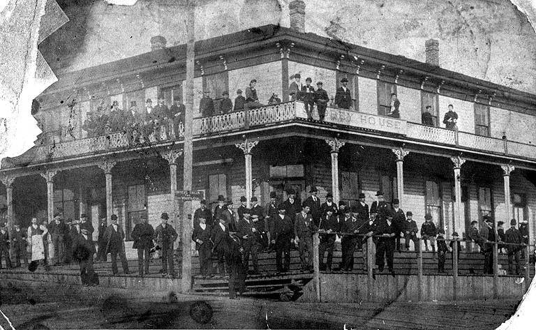
Shorey House at 3400 Fremont Ave N circa 1890, UW Special Collections photo 4415. Built in 1888, this boarding house was for Fremont’s mill workers and it was a clean, respectable place to live. After about ten years it was renamed Hotel Dixon under a new owner.
The Fremont neighborhood grew up with the city of Seattle, and its early development was largely due to its advantageous geographical position: Fremont is located north of downtown at the northwest corner of Lake Union. It was an ideal setting for water-dependent industry such as sawmills.
Fremont was also a convenient residential area because people could commute across Lake Union to downtown via boats from this early suburb. The developers of Fremont had thought of everything, and there was a boat line which went back and forth like a ferry, from Fremont to South Lake Union where commuters could catch a streetcar.
Fremont acquired its name in 1888 when it was platted by Edward & Carrie Blewett from Fremont, Nebraska. Their representatives in Seattle were Luther H. Griffith, a real estate promoter who had come from Fremont Nebraska in 1883, and local investor Edward Corliss Kilbourne from Aurora, Illinois. But long before acquiring its name, the Fremont area had already attracted the interest of Seattle’s earliest white settlers.
Fremont’s advantageous location on a stream flowing out of Lake Union
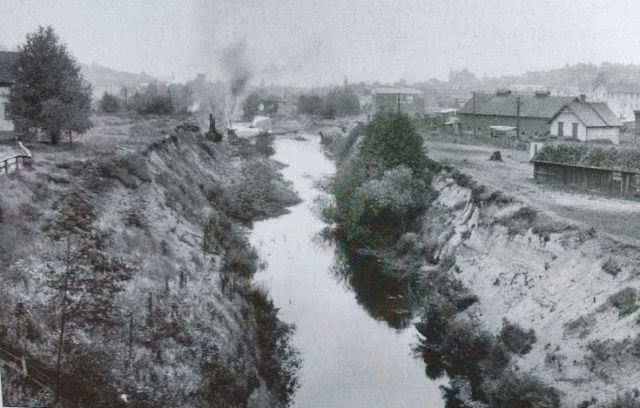
Before construction of the ship canal in 1912-1917 there was this ditch which had been created by hand-digging in the 1880s, to widen the course of a stream used for floating logs to mill. Photo circa 1912, looking west with Fremont at right. Photo courtesy of MOHAI 83.10.6934.
In what is now the Fremont neighborhood which William Strickler had already chosen as his land claim, Strickler’s survey party of 1855 noted that they stepped across a small stream. This stream was at the northwest corner of Lake Union. In the 1880s the stream was widened and was called The Outlet, and a gated “splash dam” was built at The Outlet so that water could be released with enough force to float logs from Lake Union, toward Fremont and then eventually toward Ballard.
Beginning in the 1850s Seattleites had seen that it would be possible to cut a canal and that is how Lake Union got its name: the thought was to go through and unite an east-west waterway from Puget Sound to Lake Washington. But Seattle’s pioneer canal-planners were ahead of their time; the ship canal would not be completed until 1916.
Fremont is easily reached from downtown Seattle by traveling along the west shore of Lake Union.
The Fremont Milling Company (lumber) which the land developers established in Fremont in 1888 was only the first of many activities which made Fremont a hub of business and transportation radiating out to other neighborhoods.
Edward C. Kilbourne was a co-owner of land in Fremont as well as electric streetcar lines, so he directed the routes towards Fremont. The streetcar line established Fremont as a convenient place to live, so that Kilbourne and the other investors could sell house lots. Kilbourne was also an investor in boat service over to Fremont from what is now the park, maritime and museum site at South Lake Union.
Because of its convenience, good connections and development of industry, Fremont grew with housing for mill workers and all the amenities of a neighborhood such as grocery stores, schools and churches. Fremont’s long line of historical heritage is still evident in present times, such as in B.F. Day Elementary, the oldest continuously operating school in the Seattle system.

John Ross 1827-1886
Another early resident of the Fremont area was John Ross, who filed a homestead claim in 1853. The Ross claim was to the west, contiguous with William Strickler’s Fremont claim. The John Ross claim included land on both sides of what is now the Ship Canal and the present site of Seattle Pacific University.
On the north side of the Ship Canal, Ross Playground at 4320 4th Ave NW is the former site of the Ross School which started in 1883. The school was not on Ross property but was nearby and was built in cooperation by the Ross family and their neighbors.
All Seattle-area homesteaders fled their claims during the Puget Sound Indian War of October 1855 to January 1856, and John Ross fled his land claim property on what is now north Queen Anne. Ross did not return to his claim property for more than fifteen years. By that time (the 1870s) John Ross had a wife and children and the fear of attack by Indians was in the past.
The Wedgwood neighborhood did not develop until after 1900
The Wedgwood neighborhood did not have any residents or land claimants until the 1870s. The earliest Wedgwood residents were Civil War veterans of the Union Army who came to Seattle from other states of the USA, about ten years after the end of the Civil War. These settlers came to start new lives “out West.” Because of the availability of land in Washington Territory, veterans could receive free land in credit for time served in the war.
Captain DeWitt C. Kenyon served in the Civil War for the state of Michigan. He and his family came to Washington Territory in the 1870s and filed a land claim in what is now the Wedgwood neighborhood.
In the 1870s the Weedins from Missouri and the Kenyons from Michigan (all Civil War veterans) filed homestead claims in Wedgwood. Land in Wedgwood was still available twenty years after William Strickler’s survey of 1855; no other white settlers had yet claimed it. This shows how “far out” Wedgwood was, and that because it was not located on or near a body of water, the neighborhood did not develop as an early business and transportation hub like Fremont.
Wedgwood’s homesteaders of the 1870s stayed about a dozen years and then moved on, and property records show the sales transactions of their claim properties. The Wedgwood Rock tract formerly owned by William Weedin was purchased by the Miller family. The Millers held it undeveloped for sixty years, finally selling in the 1940s to Albert Balch, the developer of Wedgwood.
All of Capt. DeWitt C. Kenyon’s homestead land claim from NE 75th to 80th Streets, 30th Ave NE to 45th Ave NE, was bought by Charles H. Baker and a group of investors in 1888. But property records do not show anyone living on the Baker investment land in Wedgwood until after 1900. Another part of the former Kenyon homestead became the present site of Eckstein Middle School.
Comparing and contrasting the development of Fremont and Wedgwood
Unlike Fremont’s early development which parallels the founding and growth of Seattle in the 1850s to 1880s, Wedgwood did not really get going as a neighborhood until the 1920s, when neighbors began organizing schools, clubs, churches and a private bus service.
Fremont was one of the earliest recipients of electric streetcar service in 1889, though electricity wasn’t available in private homes in Seattle until 1905.

Public art, such as the Troll under the Aurora Bridge, is featured in Fremont. Photo by Judie Clarridge, November 29, 2017.
Wedgwood didn’t have electricity of any kind until 1923, and got city waterlines in 1926.
Wedgwood was always a residential-only neighborhood in contrast to Fremont which had industries such as a lumber company.
Wedgwood finally acquired an identity during the residential housing boom following World War Two in the 1940s. Fremont had received its name in 1888 and had a post office in 1890.
In 1891, with a population of 5,000 people, Fremont was annexed to Seattle. Wedgwood finally got into the city limits in the year 1954 and got a post office in 1965.
Today, Fremont is known as a lively, walkable neighborhood with many small shops and many public and private art installations. Wedgwood is a car-oriented neighborhood and the business district has mostly large chain stores and banks. Wedgwood has no public art installations.
In the 1950s when the Wedgwood neighborhood was in its principal growth period, there were quite a few small, locally-owned shops. As people became more and more car-oriented, locally-owned stores in Wedgwood were replaced by gas stations, larger chain stores, supermarkets and banks.

This complex was built in 2005 on 35th Ave NE at NE 73rd Street. It originally had a pharmacy and other locally-owned shops but now has only a bank and a chain-brand exercise studio.
Today there are only two gas stations in Wedgwood, and banks have become the most numerous kind of business. There are six banks within a twelve-block stretch of Wedgwood’s business district along 35th Ave NE.
For further reference:
Annexations and city boundaries: See the Seattle Annexation Map and the List of Neighborhoods on the City of Seattle page.
HistoryLink has a number of essays about the Fremont neighborhood, including a Thumbnail History in Essay #1320. Wedgwood’s Thumbnail History is Essay #3462. Essay #10221 about the Montlake Cut by HistoryLink writer Jennifer Ott gives an excellent overview of Seattle’s efforts to dig canals for the transport of raw materials, including Fremont’s Outlet.
Land claim of Fremont: The Fremont neighborhood a unique history in that the property was tied up in legal issues until 1888, so no one lived there. Another article on this blog tells how the legal issues were resolved and lots began to be sold in Fremont in the summer of 1888 like a land-rush development with a lot of people coming in at once.
Puget Sound Regional Archives in Bellevue, WA, is the repository of the property records of King County. Original tax assessment books show that various plats were filed in Wedgwood beginning in 1888 but lots did not sell, probably due to the remote location, lack of roads and lack of accessibility by water. Fremont, in contrast, could be reached by paddling a boat across Lake Union, before any road was completed to reach the area.

Wedgwood neighborhood in northeast Seattle. Map courtesy of HistoryLink.
Seattle School histories can be found at this link in an alphabetical list.
Seattle Department of Neighborhoods has mini-history articles listed as “context statements.” The Fremont context statement was done as part of a survey of historic housing in Fremont in 2009, in which I participated.
Township 25 map of 1889: the map was intended to show the original homestead claims even if the claimant did not still own the land as of 1889. The maps of townships can be found in the Seattle Room, Seattle Public Library (downtown), at reference number R912.797K 589A.
The original, handwritten 1855 Land Status & Cadastral Survey Field Notes, Bureau of Land Management, can be read on-line. In the search form, enter Township 25 North, Range 4 East for Wedgwood south of NE 85th Street; Township 26 North, Range 4 East for Wedgwood north of NE 85th Street. Below is a page from the work of another surveyor, William Carlton, in 1858. Carlton walked along 85th Street which was the northern edge of Township 25, to continue northward and do the survey of what would become Township 26. Townships are six miles square. Township 26 ends at 205th Street which is one of the reasons why this street, where Costco is located, is the boundary line of King County.
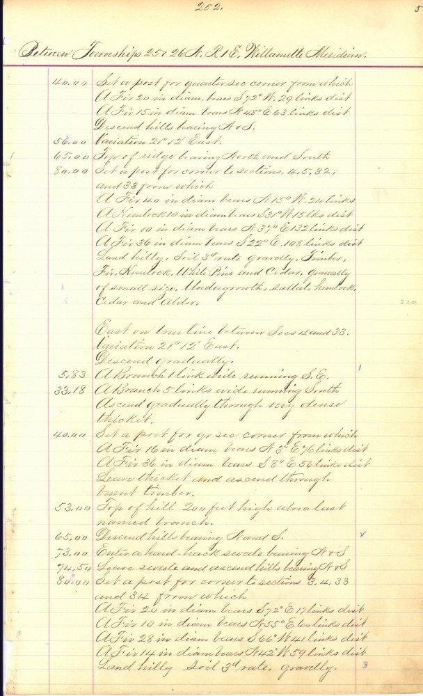
William Carlton’s hand-written field survey notes of Township 26 can be read on the Bureau of Land Management website. Here he writes on September 2, 1858 that he stood on the present 35th Ave NE at NE 85th Street intersection.

It’s difficult for me to think of two more different Seattle neighborhoods. The most apparent similarity I see is that they both seem to missing an “e” in their names.
Thank you for these interesting comparisons and contrasts.