

The Fremont neighborhood in Seattle is located at the northwest corner of Lake Union. Map courtesy of HistoryLink.
The history of the Fremont neighborhood in Seattle is unique in that the future-Fremont land was tied up in legal problems so that no one lived there until 1888. Then, with investors and promoters advertising the first one hundred lots to be sold for $1 each, in the summer of 1888 there was a land rush of businesses and residents to take advantage of the opportunity to settle in Fremont.
Fremont’s naming was unique in that it was named like a suburb, because it was still outside of the City of Seattle boundaries as of 1888. It wasn’t long, however, until Fremont’s vigorous community leaders applied to join the City of Seattle, which they did in 1891.
Before Fremont received its jump-start as a vital new neighborhood in 1888, Fremont’s land-claim history went back to the settlers who were Seattle’s eager land-seekers in the 1850s.
This blog started out in 2012 to be about the history of the Wedgwood neighborhood in northeast Seattle. Over the years as I (Valarie) have participated in other neighborhood history projects, I began posting those writings here. Go to “Fremont” in the Categories tab on the right margin of this page to find all that I have written about the Fremont neighborhood in Seattle.
The content of this article is protected under a Creative Commons Copyright. Do not copy text or photos without permission.
Seattle settlers of the 1850s
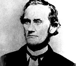
Arthur Denny
1822-1899
The first white settlers who came to Seattle in the 1850s were land-hungry people. They looked for the best sites on waterfronts, and they looked for natural resources such as freshwater running streams, stands of timber, or coal deposits.
The Denny Party were the first group of white settlers to claim sites and build cabins at what is now downtown Seattle in 1852. They had arrived in the autumn of 1851 at Alki in West Seattle, then moved over to Elliott Bay after measuring its depth and finding it suitable for large ships to come in for commerce.
We may say that the first white settlers “shoved aside” the Native American inhabitants of the Seattle area, disregarding them and staking claims for the land. Ironically, however, the settlers were very much concerned about justice and the rule of law for their own land claims. They quickly set up guidelines for the establishment and verification of claims to help put controls on the land-grabbing greed.

The City of Seattle Fremont boundaries map includes areas from 6th Ave NW on the west, to Stone Way on the east.
One of the earliest-arriving white settlers in Seattle was William A. Strickler. At age 30 in 1854, Strickler staked a land claim for the area of what is now the main business district of the Fremont neighborhood.
Strickler’s land claim was about 212 to 214 acres. Its boundaries, expressed in today’s streets, was from 3rd Ave NW on the west, to Albion Avenue (not quite as far east as Stone Way) and from Florentia Street on the south side of the Fremont Bridge, to North 39th Street. Originally there was a small stream on the property, which was made into today’s much-wider ship canal completed in 1917.
Today’s City of Seattle neighborhood boundaries map for Fremont includes a western portion between 3rd to 6th Avenues NW, which was originally part of the homestead claim of another early Seattleite, John Ross.
By virtue of his early arrival in Seattle (1854), William Strickler got a good site for his land claim, but in 1861, William Strickler disappeared and he was never heard from again. In 1868 Seattle sawmill owner Henry Yesler used his authority as a town official (Judge of Probate) to protect the Strickler property from “claim-jumpers.”
A presumptive claim
After Strickler had been missing for seven years, in 1868 two men, Edwards and Woodward, filed a “presumptive claim” for Strickler’s land. They challenged whether the property legally belonged to Strickler or to his estate, as to whether Strickler had completed the land claim requirements before his disappearance.

Henry Yesler’s sawmill, established in March 1853, was a vital part of the economy of early Seattle.
Even in those early years, the small population of Seattle settlers had already set down legal parameters for dealing with estate issues. The intent of the probate laws was to protect the interests of survivors so that property would go to them and would not be usurped by others.
In the year 1868 sawmill owner Henry Yesler was a vital member of the small Seattle community as a major business owner. In that year of 1868 Yesler also served as Judge of Probate in Seattle and he rightly used his authority to declare himself administrator of the Strickler estate. This would allow time for determination of the validity of Strickler’s land claim, and allow time to search for Strickler’s heirs, if any.
Here is the May 28, 1868 probate document signed by Henry Yesler and by Gardner Kellogg, who as postmaster served as town notary. This document is in the Frontier Justice case files which are stored at the Puget Sound Regional Archives, Bellevue, WA.
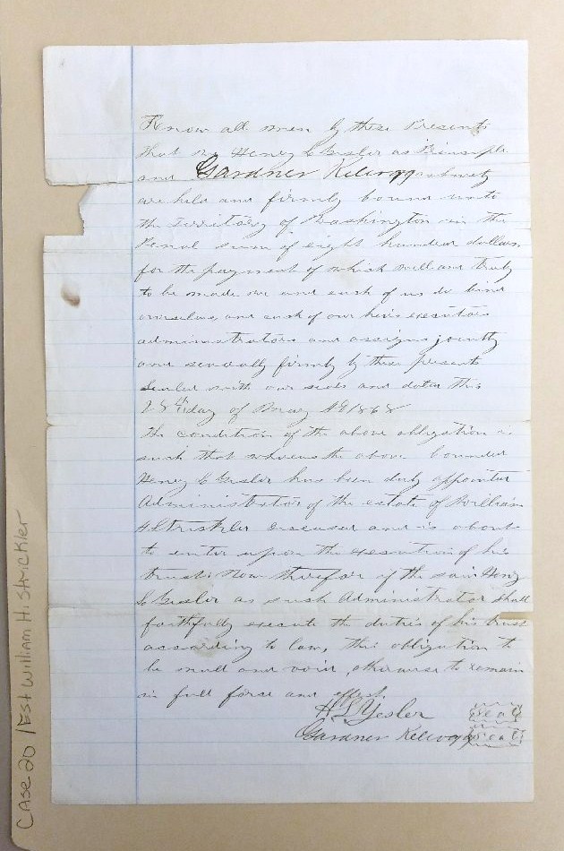
This document of May 28, 1868 declares that Henry Yesler is the administrator of the estate of William Strickler. The document is signed by Gardner Kellogg, notary. Frontier Justice Case KNG-7469, Puget Sound Regional Archives, Bellevue, WA.
Yesler engages an attorney
Henry Yesler’s next step was to engage the services of an attorney to deal with the Strickler estate issues. In that year of 1868 there was only one practicing attorney in Seattle, Judge John J. McGilvra.

Judge John J. McGilvra, undated photo from the University of Washington Special Collections
John J. McGilvra had arrived in Washington Territory in 1861, appointed by President Abraham Lincoln to be U.S. Attorney for the Territory. McGilvra lived in Olympia until 1864 and then declined re-appointment so that he could settle in Seattle.
McGilvra’s first action in the Strickler case in 1868 was to run Missing Person notices in newspapers which were published in Olympia and were sent throughout Washington Territory.
Letters for William Strickler kept arriving after his disappearance in 1861, and from these, Judge McGilvra obtained contact info for Strickler family members. A letter which Judge McGilvra wrote in April 1869 has been preserved in the Strickler family collection at James Madison University, Harrisonburg, Virginia. Here is a transcription of the letter:
Seattle, Washington Territory
April 12, 1869
To: Wm. L. Rider, Washington D.C.
Dear Sir,
Yours of the 15th was today received.
In February 1854 Wm. A. Strickler settled upon a tract of land (212 acres) about three miles from this place on the outlet of Lake Union. The next year he was driven off by the Indians. It is not certain whether he ever returned to his claim to live upon it for any length of time after that. He was after that engaged in surveying and was Registrar of the Land Office at Olympia for some years.
In 1861, he left, as I stated in a former letter, and has not been heard from since. He never proved upon said claim.
Mr. Strickler was indebted to Mr. H.L. Yesler of this place at the time he left, in the sum of $741.00. Mr. Yesler has taken out letters of administration for the purpose of proving up and entering said land for the heirs.
Recently, however, two men by the name of Edwards and Woodward have taken presumptive claims embracing the Strickler claim. We are taking evidence now to be used on the hearing of this contest in the land office at Olympia on the 17th of next month.
The case will no doubt go before the Commissioner of the Land Office at Washington by appeal, when perhaps you can be of service. The land is worth more than Mr. Yesler’s claim, and may be very valuable even.
We should be happy to receive any suggestions you have to make in the premises. I am the attorney of Mr. Yesler and shall be pleased to give you any further information.
Yours truly,
John J. McGilvra
The legal issues of the Strickler estate: proven but not resolved
In his 1869 letter to Strickler family representative Mr. Rider, who lived in Washington, D.C., Judge McGilvra stated that the Strickler case would probably have to be resolved by the Commissioner of the Land Office in Washington, D.C., and that Mr. Rider could attend the hearing in-person. One of Judge McGilvra’s other statements in his letter, that William Strickler had never “proved upon” his land claim, turned out to be wrong. After extensive investigation, the Commissioner of the Land Office was satisfied with the documentation that verified Strickler’s land claim.

Court document of 1872, illegal tree-cutting on the Strickler property. Case KNG-789, Frontier Justice Files, Puget Sound Regional Archives, Bellevue, WA.
The resolution of these issues took several years and in the meantime, one of the men who had filed the original legal challenge in 1868, got tired of waiting. In 1872 Henry Edwards, along with another man from Maine, Charles Preston, apparently thought that no one would notice if they cut down some trees on the Strickler claim property.
The court documents did not say who reported the illegal activities of Edwards and Preston, but it was likely Henry Yesler himself, who owned the only sawmill in town and who would have wondered where these two guys got the logs which they brought in. Yesler continued to protect the Strickler estate in this way, so that no matter whether heirs claimed the property or whether the land was sold, the timber belonged to the Strickler estate. The Frontier Justice case documents said that the illegal tree-cutting case was tried by Judge Orange Jacobs, and that the two men, Edwards and Preston, were ordered to pay reparations to the Strickler estate.
William Strickler’s brother makes tentative inquiries
In 1876, J.H. Strickler, one of William Strickler’s brothers, wrote a letter to Captain John C. Ainsworth, a prominent merchant and owner of a steamship line on the Columbia River near Portland, Oregon.
J.H. Strickler, who was then living in Barbour County, West Virginia, did not know Capt. Ainsworth of Oregon. In his letter, J.H. Strickler wrote that he had been referred to Capt. Ainsworth by a man who had once traveled to Oregon. He asked Capt. Ainsworth to recommend the name of a “reliable and trustworthy attorney at Seattle.” J.H. Strickler’s letter has been preserved in the Ainsworth collection at the University of Oregon Library in Eugene, Oregon. Strickler wrote,
I am a brother to William A. Strickler who some years ago was Registrar of the Land Office at Olympia. He died sometime during the war, having some claim upon some land in King County, Washington. Some three or four years ago, it was decided by the Land Office at Washington that W.A. Strickler’s heirs had the right to that land….. We wish to employ some person at Seattle to see to it, pay the taxes and give us reliable information with regard to its value. I have received a letter from Mr. John J. McGilvra of Seattle, who proposes to act as agent for us, do you know him, is he reliable and trustworthy? Respectfully yours, J.H. Strickler, March 9, 1876.”
William Strickler’s brother referred to an earlier letter which he had received from Judge McGilvra of Seattle, offering to represent the Strickler family interests in the land claim, and he asked Capt. Ainsworth if McGilvra was of good character, “reliable and trustworthy.” J.H. Strickler could not have known that Capt. Ainsworth and Judge McGilvra were business rivals, and that Capt. Ainsworth was unlikely to give a good recommendation of Judge McGilvra.
Captain Ainsworth and the railroad route

Capt. John C. Ainsworth portrait courtesy of the Oregon Historical Society, Item 8353-23.
Capt. John C. Ainsworth (1822-1893) was one of the partners of the Oregon Steam Navigation Company which had been organized in 1860. The OSN had a monopoly on steamship travel along the Columbia River, and the firm generated big earnings. Ainsworth retained his position with the OSN while also becoming the western managing director for the Northern Pacific Railroad in 1872.
During the decade of the 1870s, including the time when Strickler’s brother wrote to him, Capt. Ainsworth was locked in a power struggle with Seattle leaders including John McGilvra, about the route and the terminus of a cross-country line of the Northern Pacific Railroad. Seattleites wanted the Northern Pacific Railroad to pass through Walla Walla in eastern Washington, and then over the mountains to Seattle, so that goods could travel by rail to and from the Port of Seattle. Captain Ainsworth made sure that this route was NOT chosen.
In 1873 Capt. Ainsworth announced that the Northern Pacific Railroad would run parallel to the Columbia River as far as Portland, Oregon. Then a line would go north from Portland to Tacoma, Washington. Ahead of the final decision on the route of the railroad, Capt. Ainsworth and his co-investors bought up land in Tacoma so that the location of the rail terminal in Tacoma would be of benefit to them.
The Northern Pacific Railroad line would run ONLY as far as Tacoma, which had been chosen as the terminus of the railroad, leaving Seattle out, with no rail line to the City of Seattle at all. The struggle over railroad lines was part of the decades-long power struggle for economic advantage among businessmen of the cities of Olympia, Portland, Seattle, Tacoma and Walla Walla.
Why didn’t the Strickler heirs take action on the estate issues?
We don’t know if Capt. Ainsworth of Oregon ever sent a reply to Strickler’s brother in 1876, but we do know what happened next in the long-running Strickler legal case: nothing. Inexplicably, Strickler’s heirs did not take action to do anything with the estate. The above letter of 1876 (to Capt. Ainsworth) was written fifteen years after Strickler’s disappearance and eight years after the Strickler family had first been contacted about probate of the estate of William A. Strickler, but his brother J.H. Strickler still seemed hesitant and undecided about what to do.
We may speculate on the reasons why the relatives of William Strickler did not take definitive action to take ownership of his land claim in the future-Fremont neighborhood of Seattle. William Strickler’s mother lived until 1881 and she may have held out hope that her son would be found alive and that his land claim could be restored to him. Another possibility is that Capt. Ainsworth in Oregon did write a return letter to the Strickler family, casting Judge McGilvra in an unfavorable light. Perhaps Capt. Ainsworth persuaded the Strickler family that they should have nothing to do with Judge McGilvra or any other Seattleites.
It seems that the most likely possibility is that the Strickler family simply did not understand the value of Strickler’s land as it was too far away from where they lived in Virginia and around Washington, D.C. No member of the Strickler family ever came to Seattle in-person to see the land claim and talk to local officials. Whatever the reasons, nothing happened with the Strickler estate until a Seattle mover and shaker, Thomas Burke, found a way to resolve the issues.
A mover and shaker arrives in Seattle: Thomas Burke

Caroline McGilvra Burke circa 1895. Photo courtesy of University of Washington Special Collections 484.
In 1875 twenty-five-year-old Thomas Burke arrived in Seattle with his law degree in hand. He intended to practice law in Seattle but he had bigger ambitions, as well, to partake of the land development opportunities of the frontier city. Burke had a knack for choosing the best sites and the best opportunities.
The first thing Thomas Burke did in Seattle was to become the law partner of Judge John J. McGilvra, and in 1879 Burke married McGilvra’s daughter Caroline. The two men, Burke and McGilvra, formed an alliance which greatly influenced the development of Seattle.
Burke arrived in Seattle at a time when the city had Railroad Fever. Again and again, citizens advocated for Seattle to be the terminus of a coast-to-coast railroad, only to be let down and snubbed, such as when Tacoma was chosen as the terminus of the Northern Pacific’s transatlantic line in 1873. In 1885, led by Thomas Burke and Daniel Gilman, twelve Seattle citizens banded together to form their own railroad called the Seattle, Lake Shore & Eastern (SLS&E).

Judge Thomas Burke (1849-1925) Image courtesy of MOHAI #1559
Thomas Burke had been told the background story of the Strickler estate and he and his father-in-law, Judge McGilvra, must have strategized as to how to resolve the legal issues. Burke was very concerned about the problem because he had determined that he wanted his SLS&E railroad to run east-west through Strickler property.
Another issue was the desire of a Seattle investors group, of which Burke was also a member, to build a ship canal for transportation of heavy goods such as lumber and coal. In Seattle’s early years before cars and trucks were invented, transport of products by ship was the only realistic way to bring out natural resources such as coal. The investors group saw that Ross Creek which flowed from Lake Union westward out to Puget Sound, would be an ideal place for a canal. The creek bed could be widened and deepened so that ships could pass through – but only if the investors group could obtain the legal right to do so, crossing properties owned by others along the creek.
Burke’s involvement in both canal and railroad development led him to become one of another group of developers, that which established the Ballard neighborhood, and Burke became the resolver of the legal issues of the Ross and Strickler estate properties in the future-Fremont. All of these land areas bordered the proposed canal route and also were to have stops along Burke’s railroad. Seattleites know that the course of Burke’s SLS&E railroad is now the Burke-Gilman Trail which runs parallel to the ship canal through Fremont.
Burke resolves the Ross and Strickler estate issues to make way for the canal and the railroad

John Ross
1827-1886
The homestead claim of John & Mary Jane Ross was located just to the west of William Strickler’s property, and the Ross family was still living on their homesite as of 1885. Their house was on the north side of Ross Creek at about NW 41st Street and 6th Ave NW, and they owned land all the way to the present site of Seattle Pacific University on the south side of today’s ship canal.
In 1883 Henry Yesler, Thomas Burke and others formed the Lake Washington Improvement Company. They started on creating a canal by hiring workers to widen Ross Creek, but John Ross impeded the work because he did not want them to cross his property. The court had already ruled against John Ross in his damages case in 1883, but he still resisted. In 1884 the canal work was put on hold while the canal committee sought a restraining order against John Ross.

Mary Jane Ross
In 1885-1886 Thomas Burke represented Mary Jane Ross in a divorce action which resulted in Ross property being freed up and available for the right-of-way of the canal and of Burke’s railroad. While I would not accuse Burke of orchestrating the Ross divorce just for his own purposes, the timing was essential, both for the canal work which had been delayed, and for the beginning of plans for the Seattle, Lake Shore & Eastern Railroad.
In a memoir by Ida, the daughter of John & Mary Jane Ross, Ida told of being present when Daniel Gilman came and asked Mrs. Ross for the right-of-way across her property, for the new railroad. After the divorce was finalized in February 1886, John Ross owned the land on the south side of Ross Creek and Mary Jane on the north side. Gilman wanted the railroad route on the north side, leading east-west from Ballard which he and an investors group already owned. The work of Thomas Burke & Daniel Gilman to organize the railroad, is the reason why today’s bike path is called the Burke-Gilman Trail.
Obtaining right-of-way across the Strickler land claim property
Thomas Burke next started working on the problem of the Strickler estate, since the canal project and the railroad both depended upon getting a right-of-way across Strickler’s homestead land claim property. This future Fremont land was still vacant as of 1886 though Strickler had disappeared in 1861. The legal strategy was to force an auction of the property due to non-payment of taxes and the need of access for the canal, which the court had already affirmed as a public works project, in the Ross case.
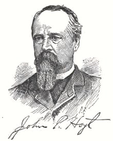
John P. Hoyt was an attorney who partnered with Seattle pioneer Arthur Denny in banking and land investments.
On July 7, 1887, Burke sued to have the Strickler homestead land sold at a King County auction, with the proceeds to be distributed to 21 heirs, mostly nieces and nephews since several of William Strickler’s siblings had died by that time.
An auction of William Strickler’s land claim was held on November 19, 1887, twenty-six years after Strickler had disappeared.
At the auction, Seattle’s founding father Arthur A. Denny and his business partner John P. Hoyt made the winning bid of $20,641 for the Strickler property of about 212 acres. After costs were paid, the court distributed the proceeds to Strickler’s 21 heirs. Now our minds are boggled at the thought of buying the entire land area of Fremont for that price of less than $100 per acre.
Denny & Hoyt’s becomes Fremont
The strange story of the Strickler estate took one more twist before being settled. In March 1888 John P. Hoyt filed a plat map for the new development, showing the layout of lots which could be sold for houses or businesses. But by the end of that same month, Hoyt accepted an unusual purchase offer from investors who came from Fremont, Nebraska.
Luther Griffith was a real estate promoter who had come to Seattle from Nebraska in 1883. During the time that Denny & Hoyt acquired the Strickler property in late 1887, Griffith alerted friends back in Nebraska about the new land area which Denny & Hoyt were going to open in Seattle. In March 1888 Edward & Carrie Blewett came out from Fremont, Nebraska and offered to buy the property. They paid $55,000 of which $43,000 was in a mortgage from Denny & Hoyt. In appreciation of their help, the plat name of Denny & Hoyt’s was kept, with legal recording of the plat’s new owners, the Blewetts, on May 8, 1888.

The Denny & Hoyt’s plat map was re-filed in May 1888 by its new owners. The top line is North 39th Street. The southern boundary is Florentia Street which today is just south of the Fremont Bridge. On the west, the plat boundary is 3rd Ave NW and on the east, Albion Avenue.
The Blewetts left development of the new Fremont in the hands of their Seattle associates including Luther Griffith and Edward C. Kilbourne, who named the streets.

Luther H. Griffith portrait circa 1891. Courtesy of UW Special Collections PH 33.6
These developers organized a logging operation and lumber company to start clearing the hillside of Fremont above the creek which flowed out of Lake Union. The Fremont Milling Company would provide employment for new residents as well as building materials for new houses. Advertising of lots for sale began to appear in Seattle’s Daily Intelligencer newspaper in the summer of 1888, and the Fremont land rush was on.
Sources
Abstract of Title: Denny & Hoyt’s Addition. Unpublished document by Greg Lange, 2007. This document traces the court cases, land transactions and timeline of how the William A. Strickler homestead claim property eventually became Fremont.
Acreage: The original government documents for William A. Strickler’s claim listed his land at 214.18 acres. Some other early documents say 212 acres. One of the earliest documents, the October 1868 survey of the Strickler claim by Arthur Denny and two other men (photo below), appraised the value of the land at $265. That works out to 212 acres @ $1.25 per acre, which was the standard price of homestead claims made by cash payment. Land in Fremont is selling for a bit more than that now!

The Puget Sound Regional Archives, repository of the property records of King County, is located on the campus of Bellevue College.
Consultations: Many thanks to all those who have listened to me babble excitedly about Frontier Justice case files, original documents and the search for William A. Strickler: Paula Becker, Greg Lange, Dr. Lorraine McConaghy, Jennifer Ott, Candace Wellman, David B. Williams, and many archivists including Phil & Midori at the Puget Sound Regional Archives.
Damages, Real Property, 1872 (illegal tree-cutting case). Case number KNG-789, Charles H. Preston and H.H. Edwards, defendants; estate of William A. Strickler, plaintiff. Frontier Justice Files, Puget Sound Regional Archives, Bellevue.
“Denny Party lands at Alki Point near future Seattle on November 13, 1851,” HistoryLink Essay #5392 by Greg Lange, 2003.
Estate, Administration of Probate of William A. Strickler, 1868. Case Number KNG-7469, Frontier Justice Files, Puget Sound Regional Archives, Bellevue, WA.
The two documents in the probate file which I have cited:
(1) Letter of administration of probate signed by H.L. Yesler and Gardner Kellogg on May 28, 1868.

In October 1868 three men did an appraisal of the value of the Strickler homestead claim property. Frontier Justice case documents KNG-7469, Puget Sound Regional Archives.
(2) Appraisal of Strickler land value signed by Thomas Mercer, Probate Judge, October 29, 1868; surveyors were Arthur Denny, Franklin Matthias and [Edward Steelman?] I recognize the names of Denny and Matthias, active citizens of Seattle, but the name of the third man is not familiar. I speculate that in order to show fairness and impartiality in the appraisal of Strickler land, the survey team might have included this man who had no interest in the Strickler property for himself. Their appraisal was $265, which is $1.25 per acre. This is consistent with the $1.25 per acre which was the charge for homestead land at that time.
Fremont Historic Context Statement by Caroline Tobin, 2010. Settlement, Land Use Patterns & Platting History, pages 8-9. Historic Preservation/Department of Neighborhoods, Seattle.
He Built Seattle: A Biography of Judge Thomas Burke, by Robert C. Nesbit, 1961. Seattle Public Library.
“Henry Yesler’s steam-powered Seattle sawmill cuts its first lumber in late March 1853,” HistoryLink Essay #760 by John Caldbick, 2014.
“J.H. Strickler inquiry for a good attorney in Seattle, March 9, 1876.” John C. Ainsworth papers, University of Oregon Library, Eugene, Oregon. Collection Number 250, Box 2, Folder 6.
“John J. McGilvra of Seattle, letter of April 12, 1869.” Box 1, Folder 4, Mr. & Mrs. James Hoover Collection of Strickler Family Papers, SC0098, Special Collections, Carrier Library, James Madison University, Harrisonburg, VA.
John and Mary Jane Ross: Their court cases are in the source list of this blog article.

Boat parade on July 9, 2017, to celebrate the hundredth anniversary of the Lake Washington Ship Canal. Photo taken from the Fremont Bridge by Valarie.
“Lake Washington Ship Canal (Seattle),” HistoryLink Essay #1444 by David B. Williams, 2017.
Partition of Property, 1887. Case Number KNG-5247, Plaintiff: Thomas Burke. Defendants: Strickler et al. Frontier Justice Files, Puget Sound Regional Archives, Bellevue, WA.
Plat maps: You can find the original plat map for the area of your house, by looking up your address on the King County Parcel Viewer. Click through to Property Detail. On the right margin is a link to the plat map. Your house will be found on the map by the lot and block number. Plats have names, such as “Denny & Hoyt’s” for the area of what became the Fremont neighborhood of Seattle.
 Edward and Carrie Blewett of Fremont, Nebraska, filed two other plats in Seattle in 1889-1890. We don’t have an explanation for this except that they must have thought that real estate in Seattle was a good investment. In 1889 they filed a plat on Queen Anne Hill called Evans & Blewett’s Addition to the City of Seattle, located to the west of today’s McClure Middle School. In 1890 they filed a plat called Blewett’s 1st Addition to Kirkland.
“Seattle, Lake Shore & Eastern Railroad Company is incorporated on April 15, 1885,” HistoryLink Essay #1735 by Heather M. MacIntosh, 1999.
“Seattle Neighborhoods: Ballard – Thumbnail History,” HistoryLink Essay #983 by Walt Crowley, 1999.
Washington Digital Archives: Frontier Justice case lists. The term “frontier justice” means the court cases which were filed before Washington became a state in November 1889. The cases are listed on-line and the actual files are in the Puget Sound Regional Archives, Bellevue, WA.
Washington Territory by Robert E. Ficken, 2002. Seattle Public Library 979.703 FIC.
Washington Territory Donation Land Claim Patents, William A. Strickler, Claim number O-529 of 1854, King County, pages 119-120. Washington Digital Archives.

In 1888 Fremont’s developers began sales of lots at about the present site of the Fremont Bridge. Photo courtesy of UW Special Collections, Asahel Curtis Item 482.

This is awesome! I love reading up on the history of my city.
Thanks, Adam, I love Seattle, too.