Gas Stations and the Maturing of the Business District in Wedgwood

Photo by Greg Gilbert, Seattle Times newspaper, May 9, 1971.

A HistoryLink article by Greg Lange tells of the large-scale layoffs of employees at Boeing Aircraft which set off a recession in Seattle from 1967 to 1972.  The population of Seattle plummeted as people left town to find work elsewhere.  Two local real estate agents thought it would be funny to put up a billboard about the exodus, saying, “Will the Last Person Leaving Seattle – Turn Out the Lights.”

Besides Boeing employees, many other people such as restaurant workers lost their jobs when the population of Seattle decreased and small businesses could not sustain themselves.  In that time period the Wedgwood neighborhood in northeast Seattle had been established and growing for about 25 years and was beginning to show signs of the end of one era and the start of another.  We can see how the slowdown in the economy affected Wedgwood at the start of the 1970s, with fewer and fewer small, locally-owned stores, and the coming of more banks and larger chain stores.  Gas stations went out of business, too, because of higher operating costs and fewer customers.

Continue reading

Posted in businesses, gas stations | Tagged , , , | Leave a comment

Wedgwood’s NE 95th Street Gas Station Intersection

In the 1940s the intersection of 35th Avenue NE and NE 95th Street had gas stations on three corners, and a used-car lot as well.   This intersection on the northern boundary of the Wedgwood neighborhood was once called Morningside or sometimes Maple Leaf, in reference to the elementary school on NE 100th Street.

There has been a gas station at 9500 35th Ave NE since 1932.  The barber shop (red building) also dates from that year.

Up until the 1940s, the intersection of NE 95th Street had more “going on” than the intersection of NE 85th Street.  For a while there were gas stations on three of the four corners of NE 95th Street, some small stores and a barber shop at the northeast corner.

To the east of the intersection of 35th & 95th there was a small grocery & pharmacy.   West of the intersection, in mid-block on NE 95th Street Mrs. Curtis had her Maple Leaf Gardens floral business.

Gradually in the 1940s and 1950s, with the development of Albert Balch’s Wedgwood neighborhood centered at NE 85th Street, the residential population grew more there and businesses began to cluster around NE 85th.  That intersection ultimately became the heart of Wedgwood, while the intersection of NE 95th Street lacked further business development.  Over time there were fewer businesses at NE 95th Street, rather than more.

Continue reading

Posted in businesses, gas stations | Tagged , , , , | 3 Comments

Gas Stations and Intersections in Wedgwood

NE 75th Street intersection.Photo by Christopher Priest of The Urbanist

Looking west along NE 75th Street from the intersection of 35th Avenue NE.  Photo by Christopher Priest of TheUrbanist.org

The Wedgwood neighborhood of northeast Seattle has a linear business district along the arterial 35th Avenue NE, with stores clustered at the major intersections of NE 75th, 85th and 95th Streets.  As the neighborhood began to take shape in the 1940s, there were one or more gas stations at each of these intersections.

Pictured at right, the Subway sandwich shop at the southwest corner of NE 75th Street & 35th Ave NE, was once the site of a gas station.

By the 1980s the number of gas stations in Wedgwood had declined sharply and they were replaced mostly by store buildings.

Continue reading

Posted in businesses, gas stations | Tagged , , , , | 2 Comments

Gas Stations and Open Space in Wedgwood: the Morningside Substation

Even in the short history of the Wedgwood neighborhood in northeast Seattle, there are some sites which have had multiple different buildings and uses over time.  One such site is the northwest corner of NE 86th Street on 35th Ave NE.  This corner first took on an identity in 1949 when it became the Morningside Electrical Substation at the back portion of the lot farthest from 35th Ave NE.  Then from 1949 to 1968 at the front of the lot, there was the M & M Mobil gas station. From 1968 to 2013 a modular building brought onto the site, was used by businesses.  Today the space is vacant, awaiting development as a pocket park.

Continue reading

Posted in gas stations, Land records and surveys, name of the neighborhood, Neighborhood features, parks, Plat names | Tagged , , | Leave a comment

Business Changes and Development Pressures in Northeast Seattle: Neighborhood Stores

Wedgwood courtesy of HistoryLink

Wedgwood neighborhood in northeast Seattle. Map courtesy of HistoryLink.

The years following the end of World War Two in the 1940s saw the rise of new kinds of stores.  Some were big supermarkets which had a much wider variety of products than traditional corner grocery stores, and some were small convenience markets where the kind of products you might want to pick up quickly, such as a bottle of ketchup, were sold.

Different kinds of stores vied with one another in the post-war retail environment.  In 1946 a chain of stores owned by the Southland Corporation, changed their name to 7-Eleven to emphasize their longer hours of operation.

Wedgwood in northeast Seattle once had two 7-Eleven stores along the arterial 35th Ave NE, but there are no more now.  More changes are coming, as a former 7-Eleven building which became Wong’s restaurant, is proposed to be torn down and replaced by townhouses.

Continue reading

Posted in businesses, Land records and surveys, Neighborhood features | Tagged , , , | 5 Comments

Gas Stations and Growth in Northeast Seattle: Gray’s Service Station

From 1936 to 1940 King County, Washington, which includes the greater Seattle area, undertook a survey of all existing buildings, both houses and businesses.  The survey was 75% funded by the federal Works Progress Administration (WPA) which helped provide jobs during the economic depression years of the 1930s.

The Puget Sound Regional Archives, repository of the property records of King County, is located on the campus of Bellevue College.

The property survey included photos which helped King County’s tax assessors assign a property tax value to buildings.  Today the collection of photos is kept in archival storage at the Puget Sound Regional Archives.

A current photo of a house or other building can be found on King County’s on-line Parcel Viewer.  To find your house, enter your address on the Parcel Viewer page and click through to Property Detail, then click on the “camera” icon.

When a building has been torn down and replaced, the old photo is kept with its previous records.  To write this article about a site in northeast Seattle which formerly had a gas station called Gray’s, I (Valarie) went to the Puget Sound Regional Archives to look at the old property photos of the corner of NE 65th Street.

Continue reading

Posted in businesses, gas stations, Land records and surveys, Neighborhood features | Tagged , , , , | 2 Comments

Searching for the Origins of Seattle Street Names

There is no resource list of the meanings of Seattle’s street names or how the street names were derived.  Even the granddaughters of Seattle city founder Arthur Denny were left to speculate on his choices of the names for twelve downtown streets.  The granddaughters wrote in their books, Four Wagons West and Pigtail Days in Old Seattle, about their memories of Arthur Denny, about early days in Seattle and what their best guess was as to the origin of the street names.  Roberta Frye Watt wrote, “Why Mr. Denny named the streets in alliterative pairs, no one knows.”  (page 107, Four Wagons West.)
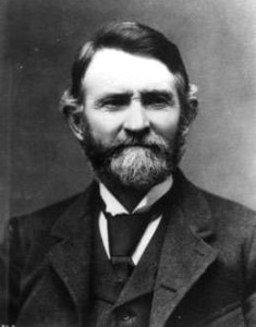
David Denny
1832-1903

Some street names are apparent in their derivation when honoring an early settler, such as Denny Way for the original homestead claim property of David Denny (Arthur’s younger brother) and Mercer Street for Thomas Mercer, an early, influential settler of Seattle.  But for some other street names, such as Aloha Street, we may feel bewildered as we wonder, what is “Aloha” for?

In a previous post on this blog, I wrote about the founding of the City of Seattle and Arthur Denny’s naming of downtown streets.  In this blog post we will consider some ways in which we might find out the reasons for other street names in Seattle outside of the downtown area.

In our first search, we will try to find the reasons for the name of Aloha Street.  Our second search will be for Cleopatra Place NW in the Ballard neighborhood.

Continue reading

Posted in Land records and surveys, Plat names, research resources, Seattle History, streets | Tagged , , , | 7 Comments

The Preston Brothers: from Maine to Seattle

After the Denny family arrived and became the founders of the (future) City of Seattle in 1851, in 1852 Henry Yesler came to inspect the site of the future city and see if it was suitable for setting up a sawmill.  Yesler was given land at what is now Pioneer Square in Seattle, and Yesler’s sawmill began operating at the Seattle waterfront in March 1853.

An 1895 view of ships loading lumber at Port Gamble’s mills. Photo 4960 of UW Special Collections.

Some of the other earliest-arriving white settlers in the Pacific Northwest were lumbermen from Maine who wanted to find easily accessible supplies of timber.  Later in the year 1853 Yesler’s mill in Seattle was visited by ten men from Maine who were in search of a place to set up a lumbering operation.  Led by Captain William C. Talbot, the men purchased heavy timber pilings from Yesler to start building a mill at their chosen site, Port Gamble in Kitsap County, across Puget Sound from Seattle.

The Port Gamble mill operations of Pope & Talbot were so successful and grew so rapidly that the operators went back to Maine on recruiting trips. The Pope & Talbot mill operators were from East Machias, Maine.  It may be that this is how the Preston brothers of Dennysville, Maine, located only a few miles from East Machias, first heard about the frontier opportunities in the Pacific Northwest.  In the 1860s and 1870s a total of six Preston brothers came from Maine and settled in the Seattle-to-Everett area.

Copyright notice:  text and photos in this article are protected under a Creative Commons Copyright.  Do not copy without permission.

Continue reading

Posted in Fremont neighborhood in Seattle | Tagged , , , , , , | 2 Comments

Fremont’s Queen City Bank

The Fremont neighborhood of Seattle started out in 1888 with some major industries including a lumber mill, tannery and iron foundry.  By the 1920s there were only two large business sites and there were other subtle signs of decline in the business climate in Fremont.  Fremont had become a mostly-residential neighborhood with a business district along North 34th Street, containing small stores, restaurants and services such as laundries and automotive repair shops.

The building at left, on the corner of 35th and Fremont Avenue was the first site of the Queen City Bank in 1922.  Photo by Valarie.

The two largest companies in Fremont in the 1920s were Bryant Lumber Mill and the McMullen Company which provided building materials and fuel.  Executive officers of these two companies joined together to form a banking business, filing an Article of Incorporation with the State of Washington on October 10, 1922.  The bank was named Queen City Bank and opened at 3424 Fremont Avenue at the southeast corner of North 35th Street.

Copyright notice:  text and photos in this article are protected under a Creative Commons Copyright.  Do not copy text or photos without permission.

Continue reading

Posted in Fremont neighborhood in Seattle | Tagged , , | 3 Comments

The Fukano Family in Fremont

In the early 1900s in Seattle, Japanese immigrants were largely confined to Nihonmachi (today’s International District) where they operated stores and restaurants. Photo courtesy of Densho.

In Washington State in the year 1910, the census showed that one out of every four residents was foreign-born.  Of the other three out of four, many were first-generation, born in the USA of immigrant parents, and having come to Washington from the eastern USA.  For that reason, in Seattle in 1910 “diversity” could be measured by whether you were of Swedish, Norwegian or German origin:  the most numerous of immigrant backgrounds.

Immigrants from Scandinavia and northern Europe, especially those who worked in logging, fishing or carpentry, populated working-class neighborhoods like Ballard and Fremont in Seattle.  They were quickly assimilated, unlike Japanese immigrants who were marked by their obvious racial difference.  Japanese immigrants to Seattle in the early 1900s were largely confined to the Nihonmachi district.

Copyright notice:  text and photos on this article are protected by Creative Commons Copyright.  Do not copy text or photos unless you ask permission first, and agree to cite the original source.

Continue reading

Posted in Fremont neighborhood in Seattle, Immigrant heritage | Tagged , , , , | Leave a comment