
The establishment of the Naval Air Station at Sand Point in the 1920s caused Sand Point Way NE to become an arterial street. Even though the naval base grew slowly at first, its presence caused northeast Seattle to hope for economic benefits of jobs at the base and commercial growth nearby.

The entrance of the Naval Air Station was at NE 74th Street on Sand Point Way NE
The City of Seattle officially named Sand Point Way NE in 1927 and worked with King County to pave the road. Today, Sand Point Way NE is a wide arterial from Union Bay Place/NE 45th Street out as far as the gate of the former Naval Air Station at NE 74th Street. North of there, the road narrows to one lane in each direction.

Sand Point Way NE marked in blue at right
In the 1920s and 1930s little corner stores and gas stations sprang up along Sand Point Way NE out as far as NE 125th Street. Due to the narrowness of the roadway north of the naval base and low population density in northeast Seattle, the little stores retained a rural aspect.
In this blog article we will look at the stores and the gas station which were at the NE 97th Street intersection on Sand Point Way NE. Nothing remains of these now, except for an auto repair shop on one corner.
The little corner groceries only lasted about twenty years or so until other kinds of food outlets, such as 7-Eleven convenience stores or large, multi-department groceries won out in the competition for customers.
The Turnure family’s westward migration
The Turnure family founders started out in New York State and began moving westward in the 1850s, like so many Americans did during the times of upheaval and change before and after the Civil War.
In the 1850s E.W. Turnure moved to Illinois where he married and started a family. The oldest of their eight children were born in Illinois and the rest of the children in Missouri. In the next generation, Frederick Grant Turnure and one of his brothers, Dallas, moved to Nebraska. By the 1920s, Frederick’s son Floyd and Dallas’ son Harold were in Seattle.

Red Cloud, Nebraska, photo by Jeff Haller.
Frederick Grant Turnure had been the proprietor of a grocery store in Red Cloud, Nebraska, but as the economic crash of the Great Depression wore on in the 1930s, he and his wife Alta made the decision to follow their sons to Seattle. Their eldest son Floyd had become a salesman for a wholesale grocery outlet and was well able to let his parents know of the economic conditions in Seattle.
By 1934, Fred & Alta Turnure were living on Sand Point Way NE in Seattle where they were running two small groceries across the intersection from each other. The Turnures lived at the southeast corner of NE 97th Street in a house at the back, and Alta ran the store at the front.
Fred Turnure was proprietor of the store at the northwest corner, 9703 Sand Point Way NE, Turnure’s Groceries.

Turnure’s Groceries was on the northwest corner of Sand Point Way NE and NE 97th Street. Photo courtesy of Puget Sound Regional Archives.
Fred Turnure died in 1946 and the Turnure Grocery Store at 9703 Sand Point Way NE evolved into a drycleaners, which was still operating in the 1950s and 1960s.

Fox Cleaners as of 1949 in a remodeled building, former Turnure’s Grocery.
Patrick J. Rooney comes to America
Patrick Joseph Rooney was 24 years old when he immigrated from County Down, Ireland, to Seattle in 1929.

Rooney’s Corner Grocery Store
At first Patrick lived with his sister Kathleen and her husband George. George worked as a gas station salesman and perhaps he was the one who helped Patrick find a job in a related business. Patrick went to work for the General Petroleum Company in its downtown Seattle office. Patrick became part of the American fabric as a citizen in 1932, and in 1935 he married a Seattle girl.
By the 1950s Patrick and his wife Margaret were living at the southeast corner of NE 97th Street on Sand Point Way NE in the store formerly operated by Alta Turnure, which was now renamed Rooney’s Corner Grocery.

Seattle Engineering Department photo of 1958, showing Rooney’s store at the southeast corner of NE 97th. This photo looks south on Sand Point Way and was probably taken to show road conditions.
The Rooney’s time at the corner store was of relatively short duration before they moved to remote Valley County, Montana, in the northeast corner of the state. The Rooneys continued to operate a small grocery store there.
Rooney’s was torn down in 1966-67 and replaced by an apartment building.
Neighborhood residents who grew up in the 1950s-1960s remember the little stores on Sand Point Way NE at NE 97th Street where children would stop by on the way home from school for snacks, or would be sent by their mothers to the store for a needed item. Today neither of the two little grocery stores at 97th are extant; they have both been replaced by apartment buildings.

Apartment building in place of the former Turnure’s Grocery Store at 9703 Sand Point Way NE. Photo by Valarie.
A gas station at 97th & Sand Point Way NE
The sharp increase of car ownership in the 1920s helped cause northeast Seattle to become a neighborhood of car commuters. Residents of the area almost certainly were car owners as there was no other way to get around.
The opening of gas stations was another indicator of the car culture of Sand Point Way NE. At the northeast corner of Sand Point Way NE at NE 97th Street, a gas station opened in 1933.
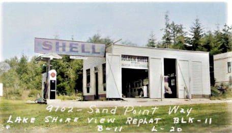
This gas station at 9702 Sand Point Way NE opened in 1933.
 Often the stores and gas stations along Sand Point Way NE had a property owner who leased out the buildings. That was the case with the Turnure Grocery at 9703 and the gas station at 9702, which were both owned by Wesley S. Newton.
The Newtons lived at 4614 NE 97th Street just west of/behind the Turnure Grocery. Mr. Newton never operated the store or gas station himself; he worked for a lumber company.
A bus service for northeast Seattle
In 1925-1926 housewives of what is now Wedgwood and Meadowbrook spearheaded the organization of a private bus service, and went door-to-door raising subscriptions.
Forrest Goodwin, bus driver, with the Northeast Transportation Service bus parked at the Goodwin home, 3248 NE 89th Street circa 1933.
Housewives wanted to travel to shopping or appointments during the daytime when their husbands were at work (men were the only ones who drove the family car).
Northeast Transportation Company was launched in 1926 with a route mainly along 35th Ave NE, to connect to other bus lines inside the Seattle City Limits. The Goodwin family whose son Forrest was one of the bus drivers, often had the bus parked at their house as pictured here.
Later in the 1930s the bus line was operated by Ran Johnson. He moved his family to NE 100th Street just east of Sand Point Way NE and he leased the gas station on the corner of 97th for parking and maintaining the bus.
Ran Johnson died in 1943 and over the years the gas station at 97th continued to modernize. Here in 1952 it is shown as Taylor’s.

9702 Sand Point Way NE in 1952.
Today there are no gas pumps but the corner of NE 97th still has an automotive repair business. The original building has been replaced with a fabricated steel building for fire safety. The current owner of Jeff’s Auto Repair operates four locations around north Seattle.

Jeff’s Auto Repair at 9702 Sand Point Way NE. Photo by Valarie.
Sand Point Way NE outside of the Seattle City Limits

A 1938 Seattle Engineering Dept. map of the city, showing the annexation dates of different neighborhoods. A “jog” can be seen at the northeast corner, where the city limits were at NE 65th Street.
Historians have speculated as to why northeast Seattle got left out of the Seattle City Limits as of the year 1910. Other north Seattle neighborhoods such as Green Lake were inside the City Limits by or before 1910. Reasons may be because Green Lake was a planned development of housing beginning in the 1880s and could be reached from downtown via streetcar line.
The north Seattle City Limit boundary went across 85th Street to include Green Lake, then took a jog down to NE 65th Street. This was enough to include the University District, Ravenna and Laurelhurst.
Northeast of those neighborhoods, as of 1910 the population was sparse. It was not until 1954 that the City Limit went all the way up to 145th Street, to include the present Sand Point, Wedgwood, Meadowbrook and Lake City.
Sources:
City Limits: The north Seattle City Limits were finally set at 145th Street in 1954. It was a gradual process through the 1940s and 1950s when election precincts voted themselves into the City. The “directional designations” changed in 1961 so that East 75th Street, for example, became NE 75th Street. At the end of my blog article about Election Districts is a source list to the dates and a map of precincts. Info about the inclusion of separate cities, such as Ravenna, is in this article about annexations. Info about the system of Seattle street names is in this article.

Mail planes at Sand Point Airfield in 1927
Street name of Sand Point Way NE: was approved in City Ordinance #52478 of February 1927, when the City of Seattle named the road as a continuous single entity up to 65th Street, which was the City Limits.
Property records: Photos from the Puget Sound Regional Archives, repository of the property records of King County. In 1937-1940, King County undertook a project to photograph every taxable structure in order to more accurately assess property taxes. See “King County Land Use Survey.” HistoryLink Essay #3692 by Paula Becker, 2002.
HistoryLink Essays:

Sand Point naval base in 1953
#365 “King County deeds Sand Point Airfield to US Navy,” by Walt Crowley, 1998.
#2303 “King County transfers 413 Sand Point acres to the US Navy on March 8, 1926,” by Greg Lange, 2000.
#2487 “Sand Point: the Early Years 1850-1920,” by Greg Lange, 2000.
#2249 “Sand Point Naval Air Station: 1920-1970,” by David Wilma, 2000.
