
Establishment of the Naval Air Station on the shore of Lake Washington in 1927 was the catalyst for street improvements and commercial development along Sand Point Way NE. The City of Seattle officially named Sand Point Way and coordinated with King County in efforts to complete the road and pave it, for better access to the naval base. With roadway improvements came more access to the area, and then little stores and gas stations sprang up along the way.

Current view of the entrance, former Sand Point Naval Air Station at 7400 Sand Point Way NE. Photo by Valarie.
Today, Sand Point Way NE is a very wide arterial from its point of origination at 45th & Union Bay Place NE, northward as far as the gate of the former Naval Air Station at NE 74th Street (present Magnuson Park).
North of the present Magnuson Park, Sand Point Way NE suddenly narrows down to only two lanes. With the aspect of a country road, Sand Point Way winds its way along, parallel to the lake shore, until ending with a curve onto NE 125th Street. This blog article will note stores and gas stations built along the road north of the Naval Air Station at NE 75th Street.
In the 1930s gas stations and corner stores were built along the road north of the naval base, but most of these commercial enterprises only lasted a few years. One of the longest-lasting was Dooley’s Tavern built in 1926 directly across from the Naval Air Station. I have written an article about it, and the rest of this article is about other stores and gas stations on Sand Point Way NE.

Looking southward on Sand Point Way NE, we see the entrance to the Naval Air Station at left, and Dooley’s at right. At the top of the photo there is now a 7-Eleven with a gas station. This photo of 1960, Seattle Municipal Archives.
A gas station at NE 95th & Sand Point Way NE

Sand Point Way NE looking northward toward its intersection with NE 95th Street. A gas station was once on this site. The brown sign at lower left marks the Thornton Creek Natural Area in preservation. Photo by Valarie, May 2021.
A place where you would not expect a gas station to be, was on Sand Point Way NE at the intersection of NE 95th Street. Today it is hard to imagine that there was ever enough room for a Texaco Station at 9495 Sand Point Way NE which seemed to be perched on the edge of a ravine. The station was there from 1939 until about 1967. In the 1950s the station operator was William Spurr, who had brought his family to Seattle from Nebraska.

Texaco station at 9495 Sand Point Way NE as pictured in 1940, looking southward. At left can be seen the railroad bridge over the road. The railroad route is now the Burke-Gilman Trail. Photo from the King County property tax assessor, Puget Sound Regional Archives.
In 1992 the City of Seattle purchased the gas station property with funds from an Open Space bond, as part of a program to protect creekside land. Thornton Creek flows through the ravine on its way to the creek’s outlet at Matthews Beach, NE 93rd Street on Lake Washington.
The Lakeside Store (Chelsea Store)
At 10601 Sand Point Way NE a little corner store was built in 1934. The building owner, Anna Schofield, did not operate the store herself; it appeared to be a property investment.
Anna Schofield’s husband was a carpenter & housebuilding contractor. The Schofields lived at 6519 19th Ave NE, next door to the Stephen Ware family at 6511. We see that when the Ware’s son, Samuel, got married in 1920 and moved to a house in Chelsea, it is very likely that the young couple’s new house had been built by Mr. Schofield. Mr. Schofield seemed to have been investing in house lots around that northeast Seattle area, including the store building at 10601 Sand Point Way NE.

Corner store at 10601 Sand Point Way NE.
In the 1930s and 1940s different proprietors operated the Lakeside Store, some for only a few years at a time. The name of the store was taken from the plat name of Lake Side City on nearby blocks. Real estate developers started selling house lots in this area in 1906, and it began to be called Lake City. At that time there was no Sand Point Way NE, but developers had put in some other nearby roads to access the house lots.
Neighborhood identity
After the new Victory Way/Bothell Way which was put through in the 1920s (today’s Lake City Way NE) the intersection of NE 125th Street & Lake City Way NE gradually became the center of what was considered the Lake City neighborhood. That intersection developed more and more commercial sites. Businessmen networked for the benefit of the district, and in 1967 they were able to get the City of Seattle to change the name of Bothell Way to Lake City Way, up to the Seattle City Limits.
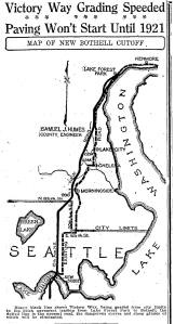
The plan for the new Victory Way in 1921 — today’s Lake City Way NE. The dotted line is the old Gerhard Erickson Road. Photo from the Seattle Daily Times of March 14, 1920, page 5.
In addition to commercial centers, another example of how neighborhood identity can be defined is via the names of Enumeration Districts given on the census.
As of 1940, the areas east of 35th Ave NE on NE 105th Street all the way over to Lake Washington, were defined as the Chelsea Precinct on the census of that year. It may be for this reason that a later proprietor of the store at 10601 Sand Point Way NE changed the name of the store from Lakeside Grocery to The Chelsea Store. Chelsea Store was listed in the phone book by that name in 1955 with Mr. Wilson, proprietor.
Mr. Wilson may or may not have been aware that in earlier years there had been a Chelsea Store at 3400 NE 110th Street, present site of the Meadowbrook Apartment building across the street from Nathan Hale High School. In the 1920s that segment of NE 110th Street was called Chelsea after the name of a real estate plat.
Then real estate promoters appropriated the name Chelsea for housing farther to the east of 35th Ave NE, so that in the 1920s, the home of young newlyweds Samuel & Jasmine Ware on 38th Ave NE was defined as being in Chelsea. The Chelsea neighborhood name also seemed to have later been adopted by the operator of the store at 10601 Sand Point Way NE.
The Lakeside/Chelsea Store at 10601 Sand Point Way NE lasted until about 1960. Today there are houses on the site and the Chelsea name is unused now for any local businesses or as a neighborhood identifier.

All signs of the Lakeside/Chelsea store are gone from the corner at 10601 Sand Point Way NE. Photo by Valarie, May 2021.
A gas station and a market at 12301 Sand Point Way NE
William Banneker was a property investor who lived near NE 95th Street and 35th Ave NE. In the 1930s he built some stores and a gas station at the NE 95th Street/35th Ave NE intersection in what later became the Wedgwood neighborhood.
Mr. Bannecker also owned property on Sand Point Way at the corner of NE 123rd Street, and his first venture there was a gas station built in 1932.

Gas station at 12301 Sand Point Way NE as photographed in 1938. Photo courtesy of Puget Sound Regional Archives.
As of 1940 the proprietors of the gas station & market were a young family who had recently come to Seattle from South Dakota. Milton Stienecker, his wife Doris and their baby boy lived on-site at the market property at 12301 Sand Point Way NE. The site was called Robison’s Grocery because Milton’s father-in-law, George A. Robison, had purchased the building for the young family to work and live in.
IGA Grocery store logo of the year 1950
Thirty-one-year-old Homer Robbins, who had been born in Seattle, became the store owner & operator later in the 1940s. Robbins had an accounting degree from the University of Washington and had worked in other businesses before becoming the operator of his market in the IGA grocery store chain. The Robbins family did not live on-site; they lived at a house a few blocks away.
Many small markets had a separately-operating butcher shop where people would buy cuts of meat to order. Homer’s IGA had the adjacent Stidell’s Meat Market with Frank J. Stidell. By the 1960s, however, the newer, bigger supermarkets were offering pre-packaged cuts of meat which consumers found more convenient.

Homer’s IGA Grocery at 12301 Sand Point Way NE
When Mr. Robbins retired, some more remodeling of the building was done and it was re-named JP’s Market.
John P. Sacco was born in Seattle in 1920 to Italian immigrant parents, Vincenzo & Adelena Sacco. The extended Sacco clan operated a market on Rainier Way in the South Atlantic Street neighborhood. John graduated from Franklin High School, served in the Korean War, married, and continued to work with the family market business.
The Sacco family closed down their market operation due to urban disruptions of the construction of the I-90 freeway, which changed the configuration of streets in the Rainier Valley neighborhood. John & Theresa Sacco moved to a house on Lake Shore Boulevard near Sand Point Way and John started a new career as operator of JP’s Market.

The former site of Homer’s IGA Grocery at the northwest corner of 123rd & Sand Point Way NE, now has a cluster of townhouses. Photo by Valarie, May 2021.
The rise of supermarkets after World War Two
After World War Two ended in 1945, there was an explosion in demand for consumer products which had not been available during the war years. Federal laws were changed so that supermarkets could offer health & beauty products and even aspirin which had previously been restricted to pharmacies. People became acquainted with one-stop-shopping at supermarkets instead of going to separate meat markets, pharmacies and other specialty stores.
Supermarket store buildings got bigger and bigger in the decades of the 1950s and 1960s. An example is the Safeway grocery in Wedgwood at the corner of NE 75th Street & 35th Ave NE. It was built in 1951 and torn down only fourteen years later, to build a bigger store on the same lot. This Safeway store is typical with its many departments such as a meat counter, a deli and a pharmacy; we don’t realize that these services did not exist within one store until the 1950s.
Northeast Seattle had always been a neighborhood of cars owners, due to its rural character with lack of bus or streetcar lines. Increasingly in the 1950s and 1960s, northeast Seattle families added second cars so that housewives were then able to drive to shop at the bigger supermarkets.
These shifts in store offerings and consumer behavior caused the decline of smaller stores and also caused the commercial growth of Lake City, where there were newer, bigger stores and a lot of shopping options clustered together. Gradually, corner groceries like the Lakeside store and JP’s Market were no longer viable.
The old-time stores are gone now

Sand Point Way NE retains the look of a country road of two lanes. Photo by Valarie, May 2021.
Throughout the 1930s and 1940s the Naval Air Station grew with more personnel, but north of the gate at NE 74th Street, commercial development never really took hold on Sand Point Way NE. By the 1960s the isolated, along-the-road stores were mostly gone.
Today the little stores and gas stations of Sand Point Way in the 1930s have been replaced mostly by apartment buildings and residential housing. There are no gas stations on Sand Point Way NE north of Magnuson Park.
Over these years, gradually the identity of the neighborhood shifted toward the greater commercial district at 125th & Lake City Way NE, with its bigger stores and more varied offerings.
Sources:

Seattle Engineering Department photo of 1958, showing Rooney’s store at the southeast corner of NE 97th. This photo looks south on Sand Point Way and was probably taken to show road conditions. In the distance we can see the gas station at the intersection of NE 95th Street.
Census and City Directories.
Property records: Puget Sound Regional Archives, Bellevue, WA.
Other stores, gas stations and restaurants on Sand Point Way NE and the story of how the road developed:
Along the Road: from Pontiac to Sand Point Way NE
Dooley’s Tavern on Sand Point Way NE
A Market on Sand Point Way NE (The Rovainen store at NE 120th)
Names in the Neighborhood: from Chelsea to Meadowbrook
Sand Point Way NE: Stores and Stations at NE 97th Street (including Rooney’s)

Sand Point Way NE on the right, in blue.

Reminds me of years ago when our mother took us on trips. Those gas stations resembled many of these.
Gas stations definitely had a smaller footprint back then. No big lots for RVs to enter; just a few bubbling pumps at the roadside. But Sand Point Way NE is a nice drive on summer afternoons.
My grandfather was Homer. Thanks for posting these pictures, this is amazing. My mom grew up in the apartment on top of the IGA.
Thank you, Valarie – my grandfather was Frank Stidell of Stidell’s meat market adjacent to Homer’s IGA; it was the last of several locations he had over the years before he retired. I grew up in the neighborhood and my sister and I would walk up to JP’s IGA frequently – although by that time (the 1970s) I don’t recall any of the other buildings you show here. (Mom’s family was from Wedgwood so I’m really enjoying your work here!)