From the earliest years of white settlers’ arrival in Seattle in the 1850s, land speculators and businessmen were attracted to what is now the Fremont neighborhood at the northwest corner of Lake Union. A big advantage of the site was a stream which early settlers called The Outlet, flowing westward toward Puget Sound. Men such as homestead claimant William Strickler hoped to use water-power to float logs on the stream, out to the Sound and toward Yesler’s Mill on the downtown Seattle waterfront.

The Fremont neighborhood in Seattle is located at the northwest corner of Lake Union. Map courtesy of HistoryLink.
Thomas Mercer suggested the name “Lake Union” at the Seattle settlers’ Fourth of July picnic on the southern shore of the lake in 1854, at where Lake Union Park is now. The “union” name was proposed because Seattle’s ambitious settlers saw that it would be possible to unite three bodies of water via a canal system.
A canal could connect from Lake Washington (on Seattle’s eastern border) through Lake Union and on westward to Puget Sound. For this reason The Outlet at Lake Union’s northwest corner was already identified at this early date as part of the ideal route of the envisioned ship canal.
Little did Seattle’s settlers know that the ship canal idea would not come to fruition for more than sixty years, completed in 1917. In the meantime, in 1887 businessman Thomas Burke and his associate Daniel Gilman set up a railroad which travelled east-west across Seattle’s midpoint. That route is today the Burke-Gilman Trail which is on the north side of the ship canal and passes through Fremont.

In 1894 Ross and Fremont were shown as place names with railroad stops. The ship canal had not yet been built but there was a creek called The Outlet from Lake Union, flowing westward. Dots on the map represent population.
Fremont bursts open for business in 1888

In 1888 Fremont’s developers had a sales sign at about the present site of the Fremont Bridge. Photo courtesy of UW Special Collections, Asahel Curtis Item 482.
Fremont was named and began to be settled in 1888 in something like a land rush, after Thomas Burke broke the legal logjam of the disputed ownership of the property.
Advertisements came out in the Daily Intelligencer newspaper in May 1888, that the first hundred house lots in the new Fremont development would be sold for $1 each.
The developers arranged for some businesses such as a lumber mill to be set up so as to create jobs, and lots for building were given to churches, as well. The developers did this to help create a livable community in Fremont which would attract residents.
Fremont’s developers, including E.C. Kilbourne and Luther Griffith, created a streetcar line from downtown Seattle along the west shore of Lake Union, to Fremont. They did this to enhance the value of their real estate and advertise Fremont as a bustling business center with convenient access to downtown Seattle. Other local developers had streetcar lines connecting from Fremont such as William Wood, developer of Green Lake, and Guy Phinney of the present zoo area on Phinney Ridge. Eventually Fremont became known as the Center of the Universe partly because of its convergence of transportation lines.
A Bridge to Fremont

Carl Signor’s grocery store is seen in this 1915 photo looking north toward Fremont. The posts of the trestle bridge can be seen. On the horizon is B.F. Day School. Photo 2787, Seattle Municipal Archives.
From earliest days there was a bridge across The Outlet, the stream which flowed westward from Lake Union. The series of bridges got bigger as the stream bed was widened, ending with the present Fremont Bridge over the completed ship canal in 1917.

In a 1904 promotional photo, Samuel P. Dixon (front) and Charles E. Remsberg are shown in their bank building at 3416 Fremont Ave N.
Years of discussion, wrangling among interest groups and government legislation took place before the route of the ship canal was determined. Fremont businessmen such as attorney & banker Charles Remsberg and City Councilmember Capt. Albert Goddard were vitally involved in the process because they believed the ship canal would be of benefit to Fremont.
During the years of ship canal construction from 1911 to 1917, some Fremont businesses benefited and some were nearly destroyed.
The grocery & feed store pictured above, benefited from its nearness to the bridge. The store owner, Carl Signor, became a hero on the day in March 1914 that he ran out into the road and stopped traffic just before a wall of water tore out the temporary trestle bridge. Waldo B. Staples was a woodworker at his home at 360 West Ewing Street until his backyard was flooded by the rising water of the ship canal. Mr. Staples seized the opportunity and created a marina business to store and service boats.

Shown here is the log pond of the lumber mill in Fremont, at the northwest corner of Lake Union. Frank LaRouche photo, UW Special Collections.
One of the issues of construction of the canal was the railroad line which paralleled the north side of the former stream system. It was not cost-effective to try to change the railroad, so the tracks stayed in place and the widening of the canal was mostly to the south.
The present ship canal was primarily completed in 1917 but it took many more years for land along the canal to “settle down” and become usable sites for construction of new buildings. In widening the canal, the 3200 block of Fremont Avenue disappeared, so that on the south side, the last street was Florentia (3000 block) before crossing the bridge. The original plat map of Fremont with the layout of streets and lots had extended to Florentia Street, so even though Florentia was on the south side of the bridge, it was considered part of Fremont.
The map of 1894 below, shows the proposed route of the ship canal west of Fremont. The canal as completed in 1917 was much wider than this preliminary drawing, so that Florentia Street became the first street on the south side of the Fremont Bridge.
On the map below, the railroad line can be seen on the north shore of Lake Union, passing through communities that had railroad stops. At top right on the map, the University of Washington campus is designated although the school had yet to move there from its original downtown location of Fourth & University (present site of the Fairmont Olympic Hotel.)

This map of 1894 shows the communities on the north shore of Lake Union.
Businesses on the south side of the Bridge

The Nickerson Street Saloon is on the triangular lot with the Bleitz to the north at 316 Florentia, right next to the Fremont Bridge. This is an intersection with heavy traffic.
As the ship canal was being completed in 1917, 25-year-old Albert Cruver watched the process with interest. He saw that the newly-created intersection on the south side of the Fremont Bridge would be an ideal place for business. Streetcar and auto traffic funneled past on their way to/from the Fremont Bridge, and there were potential customers such as the Bryant Lumber Mill at the bridge.
As soon as he could, Cruver acquired the triangle-shaped block bounded by Florentia & Nickerson Streets. In 1919 Cruver built a store on the westernmost portion of the block and opened it selling hardware and paint. The building had an upstairs apartment with a tenant.
Albert Cruver seemed to be a good businessman, alert to trends and willing to adapt his business to capture customers. With the great increase in car ownership in Seattle in the 1920s, Cruver next established a gas station on his site. It was prominently located on the eastern side of Cruver’s property where passing motorists could easily see the station and stop for gas. The City Directory of 1938 showed that he had leased the site to Earl McKale, a Fremont resident who had a chain of gas stations.
The photo below shows the site in 1948 when it began to be called the 318 Tavern. In the background is the Bleitz Funeral Home.

The 318 Nickerson Tavern in 1948, with McKale’s gas station at right. In the background is the Bleitz Funeral Home at 316 Florentia Street.
Business changes in the 1930s

Earl McKale was a Fremont resident with one of his gas stations located next to the 318 Nickerson Tavern. Photo of Seattle City Directory page for the year 1938.
Prohibition of alcoholic beverages ended nationally in January 1934. On March 1, 1934, a Seattle Times newspaper article listed Albert Cruver as one of ninety applicants to begin serving beer and wine. This was the beginning of the beer parlor at 318 Nickerson Street which at first was only called by the name of the owner, Albert Cruver.
City directory listings for the year 1938 show that the the site at 318 Nickerson Street was diversified. The gas station was listed as McKale’s, Inc., with Albert Cruver listed as the proprietor of the adjacent beer parlor. Cruver’s tenant, Thomas J. Weed, lived in the upstairs apartment of the western portion of the building and had a cigar store and cafe called Canal Lunch on the ground floor.

Approaching the Fremont Bridge, we see the visible Nickerson Street intersection with the tavern and gas station. Photo of 1949, Seattle Municipal Archives #18950A.
The Bleitz Funeral Home
Another businessman who saw the potential of the south-of-the-bridge site was Jacob Bleitz. He acquired property on Florentia Street across from Albert Cruver. In 1922 Bleitz opened a new, spacious funeral parlor located next to the south end of the Fremont Bridge and visible from all directions.

Doric Lodge No. 92 is at 619 North 36th Street in Fremont.
Jacob Bleitz moved from Wichita to Seattle in 1904 and worked as an undertaker while he surveyed Seattle’s business climate.
By 1908 Jacob Bleitz and a partner, John Rafferty, had affiliated themselves with Fremont’s Doric Lodge, a masonic group which gave businessmen a way to network with others. The Doric Lodge, which is still there today, owned this block at North 36th Street & Fremont Avenue. The lodge leased out storefronts on the Fremont Avenue side as well as the downstairs of the building. Bleitz & Rafferty opened their first funeral home at the Doric Lodge.
Even though there was another funeral home at the northwest corner of 36th & Phinney, it seemed that in the early 1900s there was enough death in Fremont for several mortuary services to share. For a time, Bleitz & Rafferty boldly set up their business at the southwest corner of 36th & Phinney, directly across the intersection from their competitor.
Bleitz & Rafferty ended their partnership in 1919 but there was still enough business for each of them to develop new sites. Rafferty moved to the 3500 block of Fremont Avenue while Bleitz began planning his new funeral parlor at 316 Florentia Street on the south side of the Fremont Bridge. That new Bleitz building, pictured here, opened in about 1922. For a detailed history of Bleitz, see the Now and Then column of June 16, 2022.

Bleitz Funeral Home in the 1930s, 316 Florentia Street. Photo from historic landmark nomination report of 2017 (see source list).
South of the Fremont Bridge: one hundred years later

Al Cruver’s tavern in 1938 has a sign with his name on it. The writing on the photo is the legal description of the site, as this photo was taken by the property tax assessors office in the 1938 survey of all taxable buildings in King County.
One hundred years after Alfred Cruver and Jacob Bleitz established their businesses on the south side of the Fremont Bridge, there have been many changes in the infrastructure of the intersection and in the types of businesses in Fremont. The gas station at the intersection is gone and there is no more cigar store.
The 318 Nickerson Tavern was acquired by new owners in 1995 and renamed the Nickerson Street Saloon. The Saloon was a nod to an old-time name, but in 1995 the Nick entered the modern era of no-smoking venues and presentation of craft beers. After twenty-six years, the Nick closed on October 31, 2021 for the site to be redeveloped.

Nickerson Street Saloon. Photo by Valarie, October 2020.
The Bleitz Funeral Home, once so prominent in the neighborhood, went out of business due to changes in societal attitudes toward death and burial. The building was bought by developers and in 2017 the new owner of the Bleitz building sought to either tear it down or make substantial changes.
The Bleitz building was brought before the Seattle Landmarks Board on March 1, 2017, which ruled that the Bleitz was worthy of preservation, and which placed some restrictions on changes to the building. The dissatisfied new owner handed off to another purchaser who was willing to preserve the Bleitz. The new owner received approval to add an adjacent new office building. The new complex is called Fremont Crossing.

Design proposal: the Bleitz renovation will be called Fremont Crossing, with an addition adjacent to the original building.
The new era of buildings in Fremont is for more height and density, and for office buildings or apartments with retail at the sidewalk level.
The Bleitz building achieved landmark status with an addition being built on its west side, but the Nickerson Street Saloon was torn down in 2022. A new, five-story apartment building took its place. Another example of adaptation to modern business trends is that this new apartment building has an adjacent coffee shop.
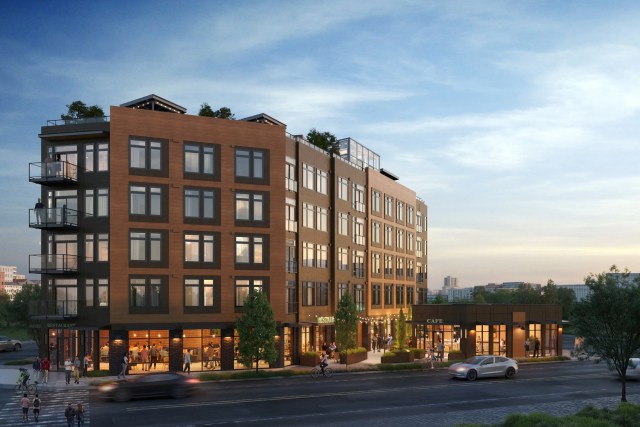
New apartment building, opening in June 2025, on the former site of the Nickerson Street Saloon.
These two buildings, the Nickerson Street Saloon and the Bleitz, represent the always-vigorous business climate of Fremont and its evolution over the past hundred years. In coming years these buildings at the southern gateway to Fremont will continue to catch the eye and will stir the imagination about happenings on the south side of the bridge.
Sources:

The Nickerson Street Saloon was demolished in 2022 and replaced by an apartment building. Photo by Valarie, October 2020.
Bleitz history: company photos in the Now and Then column of June 16, 2022.
Census and City Directory listings; newspaper search on-line through the Seattle Public Library.
Historic Landmark Nomination, Bleitz Funeral Home, March 1, 2017, Seattle Landmarks Board.
HistoryLink Essay #1445, “Seattle residents celebrate Independence Day on July 4, 1854,” by Walt Crowley, 1999.
HistoryLink Essay #3129, “Seattle’s Fremont Bridge,” by Priscilla Long, 2001.
Nickerson Street: how it got its name.
Waterway: The Story of Seattle’s Locks and Ship Canal, by Jennifer Ott and David B. Williams, 2017.
Writes of Way: a new blog featuring street names in Seattle.

The Bleitz at 316 Florentia Street was rehabbed while a new building will adjoin it on the west (to the left). Photo by Valarie, October 2020.

You can come up with the most amazing history of your area. You must spend either lots of time at your libraries or on the internet. Love those old photos. Keep digging up the interesting history;
I wish that the library and other resources were open! Everything has been closed for a year now. I’m going through my stuff at home, and there are Internet resources.
Wow, I’m always surprised by how much information you find. Fascinating article, thanks!