Residents of northeast Seattle called it “the Baskin-Robbins corner.” The five-way intersection of Union Bay Place NE is at the east end of a long block, east of the University Village shopping center on NE 45th Street.
One branch of the intersection is called NE 45th Place. The roadway angles up toward the northeast and passes under an old railroad trestle. That railroad line has been preserved as the Burke-Gilman Trail.

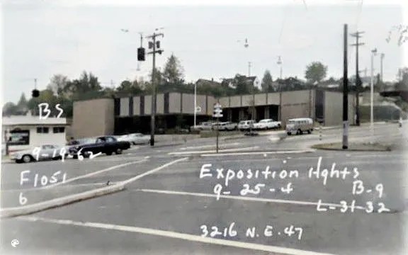
The former train trestle, now the Burke-Gilman Trail, over the roadway from Union Bay Place up to 35th Ave NE. The Exposition Heights real estate development is on both sides of the road.
Those of us who grew up in the 1950s and 1960s can remember the small stores and the gas stations at the crossroads of Union Bay Place NE. In addition to the nearby train trestle as seen in the photo above, the most outstanding landmark at Union Bay Place was the Baskin-Robbins ice cream store, one of the small buildings in a commercial district of one-story storefronts.
Today we see that the character of the Union Bay Place intersection is being transformed with the construction of one much larger building, Aegis Laurelhurst, taking up the whole block of the former Baskin-Robbins and other storefronts.

Aegis Laurelhurst under construction as of December 2022, replacing the Baskin-Robbins corner at Union Bay Place NE. Photo by Valarie.
This blog article will trace the evolution of the intersection from the first buildings built in the 1920s and 1930s.

Union Bay Place intersection marked here with the location of a new building by Aegis, a senior residence.
Northeast neighborhoods including today’s Laurelhurst, Hawthorne Hills, View Ridge and Wedgwood were late in development in Seattle history, partly due to the geography/inaccessibility of northeast Seattle. Laurelhurst, the Village of Yesler and Ravenna were the only areas which had already been named as of 1910. A portion of Ravenna closest to 15th Ave NE had been included in new City Limits, and it had a streetcar line bringing picnickers to Ravenna Park.
In the early 1900s there was as yet no ship canal and no bridges, and the inland areas of northeast Seattle were hilly and steep. The earliest activities were in the 1890s at points accessible by water, such as Sand Point (today’s Magnuson Park area). There on Lake Washington in the 1890s was a boat-building shop and Pontiac Shingle Mill.
Laurelhurst was first known as the Village of Yesler, where a sawmill was set up on the shore of Union Bay, at the present site of the Center for Urban Horticulture, 3501 NE 41st Street. The sawmill was served by a spur of the railroad extending from NE 45th Street southward to the mill.

Area map circa 1906 from page 19, History of Laurelhurst. The Union Bay Place intersection is on NE 45th Street where the corner of the University of Washington property meets Yesler.
The Alaska-Yukon-Pacific Exposition was held on the campus of the University of Washington in 1909.
By 1907 areas to the northeast of the University of Washington were starting to come to life because of news of the world’s fair event planned for 1909, to be held on the university campus. The fair was called the Alaska-Yukon-Pacific Exposition (AYPE).
News of preparations for the AYPE touched off a land rush as developers thought northeast Seattle would receive utilities and roads, as part of areas near the university. It was at this time that the McLaughlin Company bought up property and named it Laurelhurst, supplanting the former Village of Yesler designation.
So, too, the Crawford & Conover Real Estate Company thought that they could lay out a map in 1907 and begin to sell house lots in the plat they named Exposition Heights with the Union Bay Place intersection at its center. Development turned out to be very slow, but C&C was well-capitalized and could afford to hold the property long-term. The first buildings in the Exposition Heights plat were stores and gas stations built in the 1920s and 1930s along NE 45th Street and at the Union Bay Place intersection. (Note: The next article on this blog will tell about redevelopment mid-block on NE 45th Street, where a Safeway and Burgermaster will be torn down for a new complex.)
Intersection life at Union Bay Place
The Union Bay Dairy & Grocery, 3046 NE 45th Street, built in 1925, was the first business to set up at the intersection, at its western corner. Proprietor Fred Soper and his wife Berta lived on-site and both worked in the store.

Soper’s store built in 1925. This photo is from the 1938 survey of King County by the property tax assessors office. The photos are stored at the Puget Sound Regional Archives.
Both Fred & Berta came from families who had classic American stories of immigration and western migration. Fred was born in 1896 in Wisconsin of a Canadian father and American-born mother. The family moved westward until they settled in Seattle in the year 1900. Fred’s wife Berta was an immigrant from Germany.

Fred Soper’s passport application
With its visible location at the northwest corner of the Union Bay Place intersection, the Soper’s store had good customer traffic. Today this corner of the intersection has a small retail building containing a Wells Fargo and a FedEx.

Wells Fargo and FedEx at 3046 NE 45th Street, looking west. Photo by Valarie.
Beginning the gas station era at Union Bay Place NE
The first gas station at Union Bay Place NE opened in 1930 on the northeast corner of the intersection. The gas station was owned by the Ihrig family who, as of that year, had already lived a long time in northeast Seattle.
The Ihrigs were German immigrants who gradually migrated westward across the USA until they arrived in Seattle in 1883. In downtown Seattle they worked in businesses such as blacksmithing, a butcher shop and saloon-keeping.
The Ihrig family purchased property east of Sand Point Way NE, at the present site of the Sand Point Elementary School. By the 1930s the third generation of the Ihrig family were still living on-site. Two brothers, Fred Jr and Ray Ihrig, went into business together to open the gas station at 4500 Union Bay Place. Later, Ray and his bride Ida opened a tavern called Ida’s Inn at 7500 35th Ave NE.

A 1938 photo of the Ihrig’s gas station at the northeast corner of Union Bay Place. The train trestle can be seen at left. At right, is another gas station on what later became the Baskin-Robbins corner ice cream store.
Over the years the Ihrig gas station went through an evolution in its building form. At first the station could be described as “roadside novelty architecture” with its whimsical castle structure. Years later the charming wood-frame building was replaced with the classic icebox style metal-walled station.
The station was still there in 1946 when it began to be crowded by the Lakeview Medical building. The gas station lasted into the 1960s. After the gas station was gone, in 1967 Lakeview Medical expanded with an addition, all the way to the corner of the intersection.
Lakeview Medical building showing the gas station at left, still on the corner in 1962. At far right is the corner which later became Baskin-Robbins ice cream store.
The Baskin-Robbins corner
Northeast Seattle was always car-centric because it was never reached by a streetcar system (except for Ravenna, where a streetcar line ended at NE 55th Street.) From earliest years, northeast Seattle residents drove cars and this may be one reason for the proliferation of gas stations.
After the Ihrig gas station on the northeast corner of the Union Bay Place intersection, the second station to be built was on the southeast corner at NE 45th Place, with address 3200 NE 45th Street. The station, built in 1936, is visible at right in the background, in the 1938 photo of the Ihrig station (above).

Stenerson gas station built in 1936 on the future Baskin-Robbins corner, 3200 NE 45th Street.
The first owners of the gas station at 3200 NE 45th Street were the Stenerson family. In contrast to the Ihrigs who were long-time residents, the Stenersons did not stay long in Seattle. Despite changes of ownership, this gas station did last until the 1960s. It was torn down to build a small commercial structure in 1969. In 1975 that building became the Baskin-Robbins. The ice cream store was so popular that even today though the store is gone, northeast Seattle residents refer to this corner as Baskin-Robbins instead of Union Bay Place intersection.
Evolution of the intersection
Sadly the Baskin-Robbins at Union Bay Place closed in 2015, after forty years in business. The owners’ stated reason for closing was that they were forced out by increased rent. New owners of the property let it stand vacant until 2017; then the Aegis corporation bought the entire corner.

Aegis Corporation plan showing the vacant Baskin-Robbins building. The new Aegis building takes up the entire block where there were once small offices and stores.

Benton’s Jewelers was on the NE 45th Street side of the block. The globes of the street clock are visible on the sidewalk. As of 2023 this entire block was replaced by a large Aegis senior living building.
There had been small, one-story commercial buildings on both sides of the block, including Benton’s Jewelers facing NE 45th Street, to the east of Baskin-Robbins.
As part of the process of redevelopment of the block, Aegis purchased the Benton’s street clock and had it sent for restoration and storage during construction of the new Aegis Laurelhurst building at 3200 NE 45th Street.
As of December 2023 the Benton’s street clock was set up again. Street clocks are “landmarked” under Seattle’s historic preservation program and are required to be placed in public view. Construction of the new Aegis Laurelhurst building was completed in 2024.

Benton’s street clock is in place of the former Baskin-Robbins site, now Aegis Laurelhurst. Photo by Valarie, December 2023.
Then and now at Union Bay Place
The Union Bay Place intersection evolved from its early history of little stores and gas stations in the 1930s, to the one-story commercial structures of the 1940s-1960s. In 2023 we entered another phase of history of buildings at the Union Bay Place intersection, with a new Aegis Laurelhurst under construction. Construction photo here, from Excel Pacific project webpage.

Aegis Laurelhurst building under construction in 2023. At left is Lakeview Medical. The corner at the bottom of the photo is the former Baskin-Robbins site. Photo from Excel Pacific.

What a cute little Tudor gas station! I never knew about this, and I live just a couple of blocks away.
Unfortunately the property records did not show when this station was replaced with the “icebox style” metal buildings which we recognize as gas station architecture. Those of us who grew up in the 1950s and 1960s can recall only a few wood-frame gas stations as by then most had been replaced.
I wish my mother were still with us; she would remember (the sixties). Of course we always used the Mobil station with the “flying horse” on 45th.