

In 1858-1859 William H. Carlton led a survey team and drew this map of Township 26, north Seattle from 85th to 205th Streets.
On September 2, 1858, a team of surveyors stood at what is now the center point of Seattle’s Wedgwood business district on 35th Ave NE at NE 85th Street. The survey team of the year 1858 consisted of two chain carriers (men with a measuring device like that used to measure yardage in football games), two ax men who helped chop through underbrush, and the leader of the team listed as compass man, William H. Carlton.
Carlton’s hand-written field notes tell that the men set a post at this intersection because it was an important marker as they walked the east-west line between Township 25 which had already been surveyed from downtown Seattle out northward as far as 85th, and Township 26 which Carlton’s team surveyed in 1858 to 1859. That line between the two townships is now NE 85th Street at Wedgwood’s main business district along 35th Ave NE.
This blog post will tell why NE 85th Street is an important line and why the two halves of Seattle’s Wedgwood neighborhood, north and south of NE 85th Street, are somewhat different.
Wedgwood centers itself in the 1950s
The Wedgwood neighborhood has a commercial district along the north-south arterial of 35th Ave NE as a result of zoning decisions made in the 1950s by the Seattle City Planning Commission about where businesses could be built. The regulations required that businesses be clustered at the major intersections rather than spread out along 35th Ave NE. For this reason stores were built only at the intersections of NE 75th, 85th, and 95th Streets.

It is easy to have a nice day in the charming Wedgwood business district centered on NE 85th Street along the arterial 35th Ave NE.
Along with the business district, Wedgwood’s concept of itself as a distinct neighborhood also developed gradually, especially during the 1940s and 1950s with the work of Albert Balch who built houses in land plats named Wedgwood. The first cluster of Wedgwood houses was between NE 80th to 85th Streets on the west side of 35th Ave NE.
By the 1950s Balch owned three of the four corners of the intersection of 35th & 85th, and he reserved them to make Wedgwood a convenient neighborhood with grocery stores, gas stations, the “Sir Wedgwood” restaurant, medical/dental offices, barber shops and many other small stores.
Beginning in 1945, many of the businesses at NE 85th Street began naming themselves “Wedgwood” because they were surrounded on both sides of 35th Ave NE by Balch’s Wedgwood housing developments. Listings in the phone book show that the former Hansen’s Tavern at 8517 35th Ave NE, having undergone remodelling, changed its name to Wedgwood Tavern in 1945 or 1946, the first business to do so. During the 1950s the business district at the NE 85th Street intersection became the heart of Wedgwood, as it is today.
The defining event: school attendance boundaries

Wedgwood School opened in 1953 with all-portable classrooms while the permanent building was under construction.
The event that seemed to confirm Wedgwood as the neighborhood name and identity was the building of an elementary school on NE 85th Street at 30th Ave NE, just west of the 35th Ave NE center-point commercial district. The school opened (with portable buildings only) in September 1953 and was officially named Wedgwood Elementary in April 1954 even before there was a permanent building. That shows how evident it was, that the neighborhood was characterizing itself as “Wedgwood.”
Wedgwood School attendance boundaries were set between NE 75th to 95th Streets and by the end of 1956, the Wedgwood Community Club followed suit and defined the Wedgwood neighborhood with the same boundaries.
The two halves of Wedgwood, north and south of NE 85th Street
Today Wedgwood still has the same defined boundaries from NE 75th to 95th Streets but a look around the neighborhood reveals differences in the two halves of Wedgwood, north and south on either side of NE 85th Street. Up until the 1950s, children who lived north of NE 85th Street attended a school in the Shoreline District, Maple Leaf, which was on NE 100th Street just west of 35th Ave NE. While a Wedgwood mentality was growing from NE 75th to 85th Streets, north of 85th the neighborhood had been called Morningside and had an outside-the-city rural feel.

A 1953 view of NE 81st Street in the original Wedgwood emphasized its natural setting in tall trees. Photo by Werner Lenggenhager in the Seattle Public Library Historic Photos Collection.
Albert Balch’s original Wedgwood group of houses was from NE 80th to 85th Streets, 30th to 35th Avenues NE. It was a completely-finished housing project with 200 homes all built on the same scale, within five years-time from 1941-46, with all streets, sidewalks, and utilities put in. The houses all had the same set-back from the street and were in similar, but not identical styles, which gave the development a harmonious appearance.
On both sides of 35th Ave NE between NE 80th to 85th Streets the blocks are quite uniform where there are clusters of houses built by Balch in the 1940s and 1950s. In contrast, north of NE 85th Street there is a wide range of house styles built over many decades, beginning one hundred years ago when the Morningside Heights plat was advertised.
Early real estate developments north of NE 85th Street

The northwest quadrant of Wedgwood from NE 85th to 95th Streets has houses built in the 1920s.
Some of the oldest houses in Wedgwood are in the Earl J. McLaughlin and Morningside Heights developments which were promoted by real estate companies in the early 1900s. There in the northwest quadrant of Wedgwood, west of 35th Ave NE between NE 85th to 95th Streets, are some vernacular-style small houses, farmhouse styles and Craftsman-style houses built in the 1920s.
The real estate promoters of Morningside Heights gave a free set of house plans to buyers in the development. Although it was not required to use the plans, many did, and this is the reason for the larger number of Craftsman-style houses in the northwest quadrant of today’s Wedgwood neighborhood.
Some of the streets in northwest Wedgwood, up to NE 95th Street, still have a rural aspect as one can still see how the 1920s houses were spaced farther apart. In the older section of what became Wedgwood, in the 1920s homeowners often owned more than one lot and used the space for vegetable gardens, chickens, woodsheds and other semi-rural use.

A Craftsman-style house, built in 1926.
Early Wedgwood residents were car owners but Craftsman houses in Wedgwood did not have attached garages. The car’s gasoline engine was thought to be a fire danger so Wedgwoodians of the 1920s had free-standing garages set at a distance from their residence. In later years there was “infill” housing as the extra lots were sold and newer houses were built on smaller lots between the older houses.
The beautiful Craftsman home pictured here was built by Frank & Martha Hawks in 1926. Frank was a building contractor who found plenty of work where real estate promoters were selling lots in the northwest quadrant of the neighborhood, called Morningside Heights. After Frank died, Martha became a real estate agent specializing in northeast Seattle.
Why the line at NE 85th Street?
Other characteristics of Wedgwood north of NE 85th Street which have carried over from early days are a lack of finished streets (no curbs or sidewalks, a lack of grading and drainage) and the presence of curbside mailboxes. Mail delivery in south Wedgwood is house-to-house; north of NE 85th Street, mail is delivered by truck to the boxes. Why is this? Why is there seemingly a line drawn at NE 85th Street so that conditions are different in north Wedgwood?
Drawing a line at NE 85th Street
Seattle’s earliest white settlers in the 1850s were “land hungry” people. They knew that if they were among the first homesteaders to arrive and make land claims, they could harvest natural resources such as timber and coal. Then, over time, the land would become more valuable for development as the city grew up.

Seattle in 1855. See map info in Source List at the end of this article.
Among Seattle’s earliest arrivals in the 1850s was William A. Strickler. In 1855 Strickler applied to the US Government Land Office to do a survey, meaning that the land in the Seattle area would be marked into sections so that homesteaders could file land claims. The story of the survey party’s summer visit to Sand Point on Lake Washington is told in HistoryLink Essay 2215 by Greg Lange, Seattle history and property research expert.
William Strickler’s survey team included two ax men who helped make way by chopping through branches and underbrush. There were two chain men who carried a measuring chain like the goal measuring tool used in a football game. One man held the compass to guide the survey along straight lines. All of the handwritten field notes of the survey parties have been preserved and can be read on-line on the Bureau of Land Management website.
William Strickler’s survey team walked in grid patterns to mark out sections so that homesteaders could file land claims. The surveyors did not walk on lines for every street, but only along major markers of the grid such as NE 65th, 75th, and 85th Streets. No streets were actually put through at that time; the basic survey was done so that people could identify plots of land and file claims. This first survey in Seattle was designated as Township 25 and it extended from downtown Seattle as far northeast as NE 85th Street, which today is in the heart of Wedgwood.

William Strickler’s survey notes of 1855 tell us that the crew walked eastward on what is now NE 85th Street, but Rite-Aid wasn’t there then.
It is likely that William Strickler and his survey crew were the first white men ever to walk through what is now the Wedgwood neighborhood in northeast Seattle. We can visualize the men standing at the intersection of 35th Ave NE and NE 85th Street and setting a post to mark the north line of Township 25. The men could never have imagined a “Rite-Aid,” or the grocery store, coffee shops, restaurant, banks and other stores now located at the intersection. Strickler’s crew would have benefited if there was such a thing as Rite-Aid in 1855: they would have liked to be able to buy some mosquito spray, bottled water and snack bars. But there was no Rite-Aid, so the men had to build campfires, hunt for something to eat and sleep on the ground at night during the weeks of the survey.
Because 85th Street was the northern limit of the original survey of Township 25, for nearly one hundred years 85th Street was considered to be as far as Seattle would ever grow. Finally as of January 14, 1954, the city limits were set at 145th Street in a straight line from Puget Sound to Lake Washington. Today the southern half of Wedgwood is in Township 25, up to NE 85th Street, and the northern half of Wedgwood is in Township 26. That is why Wedgwood houses north of NE 85th Street have curbside mailboxes, because up until 1954, Township 26 had been a rural delivery route outside of Seattle instead of the door-to-door walking route of mail for houses south of NE 85th Street.
Seattle’s growth takes a hit in 1856

Seattle settlers took refuge in a blockhouse on January 26, 1856. Painting by Emily Inez Denny courtesy of MOHAI.
William Strickler’s survey party of 1855 started out during summer’s good weather and finished before the storms of winter. Other kinds of storms were also brewing that year in unrest which came to be called the Puget Sound Indian War. The story of that turmoil is too complicated to be told here, but for the white settlers of Seattle, things culminated in the Battle of Seattle on January 26, 1856. Although the Seattle settlers were fired-upon for “only” one day, being shot at for “only” one day was plenty long enough. Almost all of their houses were burned down by the attackers and some of the white settlers chose to leave Seattle. The remaining group of Seattle settlers had to spend the rest of the winter in the blockhouse. Arthur & Mary Denny’s house still stood at what is now First & Marion Streets but it had been looted with all tools, food supplies and anything else of value taken out. Arthur Denny wrote of those experiences:
King County, at the commencement of hostilities, was in a fairly prosperous condition, but now all was in ruins. The entire population was compelled to seek shelter and safety in Seattle or elsewhere, and a great many were so discouraged that they left the country. The war continued until the fall of 1856…..

Arthur Denny 1822-1899
Those who remained until the close of the war were so discouraged, and so much in dread of another outbreak, that they were unwilling to return to their homes in the country and undertake the task of rebuilding them. As a consequence it was years before we recovered our lost ground to any great extent.
Business was generally stagnant. Little in the way of building or improvement was attempted. Roads that had been opened before the war had mostly become well nigh impassable, and some of them entirely so. Active efforts were not resumed to improve our roads and open communication with the country east of the mountains until 1865, a period of ten years. (page 77, Pioneer Days on Puget Sound by Arthur Denny)
The 1858-1859 survey of Township 26

William Carlton’s hand-written field survey notes can be read on the Bureau of Land Management website. Here Carlton writes on September 2, 1858, that he stood on the present 35th Ave NE at NE 85th Street intersection.
The population of Seattle and King County declined after the Puget Sound Indian War and it was a long time before more people chose to come to the area again. For this reason, after William Strickler’s survey of Township 25 in 1855, another four years went by before areas north of 85th Street were surveyed to make it available for homestead claims. Finally when the survey was done to create Township 26, a professional survey engineer employed by the federal land office was appointed instead of a local person as had been done by Strickler and his crew of local men for Township 25. The surveyor who led the Township 26 marking in 1858-1859 was William H. Carlton of the U.S. Topographical Engineers, a federally-created military corps.
On the census of 1860 William H. Carlton was listed in residence in Olympia, along with other engineers of the Surveyor General’s office for Washington Territory. In addition to the survey of Seattle north of 85th Street, Carlton’s name is on other surveys and maps done over the ten years he spent in Washington Territory.
About 180 miles southeast of Seattle, in the shadow of Mt. Rainier, Carlton Pass and Carlton Creek were named for William Carlton because he was the first white man to discover it in 1867. Carlton was surveying the area to try and find a route across the mountains which could be developed for a railroad. Carlton ranged widely over Washington Territory and he is also known for his work in creating the 1857 map of Indian Nations and Tribes of the Territory of Washington.
Holding the line at NE 85th Street

The new Seattle City Council District system cuts Wedgwood in half at NE 85th Street.
More than 150 years after the surveys of Townships 25 and 26, NE 85th Street is still an important line in Wedgwood. Differences in the lot sizes, types of houses and street conditions between north and south Wedgwood have never been entirely erased.
In 2015 an important line was once again drawn at NE 85th Street for the new Seattle City Council Districts. Under the new system of elections, Wedgwood south of NE 85th Street is in District 4 (shown in blue on the map at right) and north of NE 85th Street is in District 5 (marked in pink on the map.) The districts were drawn to include approximately 90,000 people each. We see that District 5 (pink) is geographically larger, and this is because of the low population density of the area of north Seattle which was out of the city limits for so long.
Wedgwood community activists hoped that these new district divisions would strengthen representation for the neighborhood, since the interests of Wedgwood were to be included in both Districts 4 and 5.
Then a few years later a new redistricting was done, to make adjustments for population growth as well as alignment with neighborhood boundaries. The map below will go into effect in January 2024. It shows Wedgwood up to NE 95th Street which has always been perceived as the transition point between Wedgwood and Meadowbrook.

Seattle City Council Districts as of January 2024.
Sources
Pioneer Days on Puget Sound by Arthur Denny, 1887; 1979 edition with introduction. Seattle Public Library, 979.7.
Land office history: http://www.blm.gov/or/pubroom/lohistory.php
Bureau of Land Management/Land Status & Cadastral Survey Records: original written survey notes of the 1850s: http://www.blm.gov/or/landrecords/survey/ySrvy1.php
Portion of the map of the Indian nations and tribes, drawn by William H. Carlton in 1857, Washington State University Digital Collections: http://content.libraries.wsu.edu/cdm/singleitem/collection/maps/id/419/rec/3
Seattle in 1855-1856 map by Lt. Phelps, courtesy of UW Special Collections item number SEA 1382. David B. Williams, geologist, has written about this map. See also HistoryLink Essay #11045 which David B. Williams wrote on March 24, 2015 about the map.

The Herkenrath house, pictured here in 1958, was on the present site of the Wedgwood Post Office. Photo #75875, Seattle Municipal Archives.
An example of a Seattle City Planning Commission decision on the clustering of businesses at major intersections: The 1958 decision to turn down the application to build a grocery store in mid-block at the present site of the Wedgwood Post Office: Photo # 75875 and Clerk’s File #233832, “Petition of Commercial and Industrial Development Corporation for rezoning of portion of Oneida Gardens Addition on 35th Ave NE and E. 80th,” Seattle Municipal Archives, Third Floor, City Hall.
HistoryLink Essays:
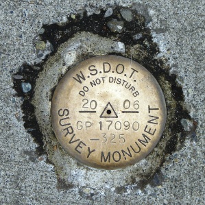
Brass survey markers are still used today, such as this marker at the Eastgate Freeway Park & Ride station in Bellevue.
“Sand Point on Lake Washington is first surveyed on August 29, 1955,” HistoryLink Essay #2215 by Greg Lange, 1999.
“Native Americans Attack Seattle on January 26, 1856,” HistoryLink Essay#5208 by Walt Crowley and David Wilma, 2003.
William H. Carlton leads survey crews in northwest Seattle (Greenwood and Crown Hill) in 1859, HistoryLink Essays #3145 and #3146 by Greg Lange, 2001.
“Seattle annexes the area north of N. 85th Street to N. 145th Street on January 4, 1954,” HistoryLink Essay #7514 by David Wilma, 2005.

Thanks for another engaging post. I find it interesting that rules “required that businesses be clustered at the major intersections rather than spread out along 35th.” Do you know the reason for this rule?
It was stated in a zoning decision, referenced in another article on this blog, that businesses should be clustered at intersections and the mid-block areas should be left for residences. https://wedgwoodinseattlehistory.com/2012/06/07/from-herkenrath-to-hunters/
The Clerk’s File mentioned in the reference, is on a square of microfiche and can be requested without an appointment at the Seattle Municipal Archives research room, Third Floor of City Hall.