

The Wedgwood neighborhood in northeast Seattle is defined as from NE 75th to 95th Streets. Wedgwood has a linear commercial district along 35th Avenue NE.
Today’s Wedgwood neighborhood is defined as extending from NE 75th to 95th Streets along the central arterial of 35th Ave NE. These “boundaries” are arbitrary but were suggested by the City of Seattle Department of Neighborhoods in the 1980s to help give neighborhoods a sense of identity and pride of place.
Before Wedgwood began to coalesce and gain an identity as a neighborhood in the 1940s-1950s, the area was made up of disparate sections of land under different plat names. This blog post will tell how some plats (sections of land) were developed in an organized way, such as the first Wedgwood plat by Albert Balch. In contrast to what Balch had done, the nearby plat of land owned by the Washington State Office of the Commissioner of Public Lands did not have an overall scheme of development. It remained rural with not all streets put through, into the 1950s.
Copyright notice: the text and photos of this article are protected under Creative Commons Copyright. Do not copy without permission.
From plats to neighborhoods
A plat is a section of land, any size, for which a plan of streets and lots is laid out. Plat maps are filed with King County and are given a name. Many of the neighborhoods of northeast Seattle are derived from their first plat name such as Laurelhurst, Hawthorne Hills and View Ridge.

Charles Baker shown in an Argus magazine cartoon, sitting on Snoqualmie Falls and holding the electric lines of a streetcar.
Several plats were filed in the (future) Wedgwood area in the year 1890 but these were not successful as developments. Charles Baker filed the Oneida Gardens and State Park plats in 1889-1890, and Baker served as surveyor on the Pontiac and Manhattan Heights plats filed by Joseph Doheny. Mary J. Chandler named a plat after herself in 1890, and today the Picardo P-Patch is on some of that land.
These real estate speculators of the 1890s (Baker, Chandler and Doheny) were too early and too optimistic in their hopes of selling land in their plats in remote northeast Seattle. In the 1890s the future Wedgwood area was too hard to reach because it was inland, was not located on a body of water which was the main means of transportation in Seattle’s early years, and was never reached by a streetcar line. The lots in these 1890s plats did not sell.
It was many more years until people began to come and live in the (future) Wedgwood. It was not until roads began to be put through and more people had cars, that people really began to populate northeast Seattle. The area remained semi-rural until well into the 1950s. Residents of northeast Seattle always were very car-dependent because there was very little access to public transportation. Local residents even organized their own subscription bus service in 1926 to help people get around.

Morningside Heights real estate brochure of 1923.
One of the first examples of development of housing in the (future) Wedgwood area was in the 1920s when a real estate company, Burwell & Morford, filed a plat called Morningside Heights from NE 90th to 95th Streets.
Burwell & Morford put in streets and utilities in their development and along with selling lots, they gave away sets of house plans. They hoped that new residents of Morningside Heights would use the house plans to build good-looking homes. This is the reason why there are so many traditional Craftsman-style houses in Morningside Heights in the northwest quadrant of Wedgwood.
The first Wedgwood-named plat

Albert Balch, Seattle Realtor, in 1961. Seattle Post-Intelligencer photo courtesy of MOHAI, Item 86.5
Wedgwood, which became the name of the neighborhood in the 1940s, started out as just one plat of land on the west side of 35th Ave NE between NE 80th to 85th Streets. This group of houses built by Albert Balch was the first coordinated development in the area with all the houses in consistent scale and style, so that the plat of 200 homes was harmonious-looking.
The book Shaping Seattle Architecture states that Balch became one of the most influential Seattle builders of the 1940s-1950s because of his coordination and oversight of developments with proper site preparation, overall layout, attention to architectural details, and installation of amenities such as sidewalks.
Albert Balch did not set out to deliberately name the whole neighborhood “Wedgwood.” In the 1940s nearby businesses began to name themselves “Wedgwood” and the name caught on. In 1954 the name Wedgwood was chosen for the new elementary school, which seemed to solidify Wedgwood as the name of the neighborhood.
A government-owned plat

The Wedgwood Safeway is at the intersection of 35th Ave NE and NE 75th Street.
Most of the plats in northeast Seattle were owned either by real estate companies, by developers like Albert Balch, or by individuals who sold lots but who did not build houses.
One plat in today’s Wedgwood is unique because it was owned by a government department, the State of Washington’s Office of the Commissioner of Public Lands. Today one corner of that plat is the site of the Wedgwood Safeway grocery store at the intersection of NE 75th Street and 35th Ave NE.
Public land to support schools

Township 25, land designation in northeast Seattle. The empty space in the middle marked “school” is the Office of the Commissioner of Public Lands plat.
When Washington became a state in the year 1889, the federal government gave some sections of land to be used for the support of schools. This didn’t always mean that a school was to be placed on the site, although this did happen with the University of Washington in Seattle; the university was built on a section of land designated for school-support.
Another section of land given for the support of schools was in the heart of northeast Seattle between NE 65th to 75th Streets and from 35th Ave NE eastward to 50th Ave NE. The top left corner of this tract is today the site of the Wedgwood Safeway store.

In early Wedgwood some families had small farms. Cartoon by Bob Cram in the neighborhood newsletter.
When these sections of land were gifted by the federal government, the thought was that the natural resources of the land would be profitable, generating revenue to support the school system. It was thought that the land would generate income from mining claims, sale of the timber or use as farmland. This proved to be unrealistic. In our imagination, we might envision coal mines or oil rigs in the Safeway parking lot? Or vast stands of timber being harvested, or a farm of many acres growing crops so profitable that they would generate enough income to support the school system?
As previously mentioned, land in the (future) Wedgwood was slow to be developed because it was too remote; too far from downtown Seattle and lacking roads. Even timber harvest would have been impossible in the 1890s on the Commissioner of Public Lands/future Safeway site, because it was too far from water where logs could be floated to mill, or a railroad to carry the logs away.
Commissioner of Public Lands files a plat in 1910

The plat of the Commissioner of Public Lands was filed in 1910. The left margin is 35th Ave NE and the right margin is 50th Ave NE. The bottom line is NE 65th Street and the top line is NE 75th Street. Today’s Wedgwood Safeway is in the top left corner.
By 1910 the Commissioner of Public Lands seemed to think that northeast Seattle was starting to be more populated and that they could file a plat and begin to sell lots. The plat map shown above, has five-block squares with only a few streets marked, such as 35th, 40th, 45th and 50th Avenues NE. In effect the plat layout had “not enough streets” which is the reason why, as late as the 1950s, some streets still were not put through in this area.
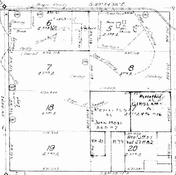
The top left corner of the Public Lands plat is the site of Safeway at 35th Ave NE and NE 75th Street. The bottom right corner shows the Gebaroff and Girolamo house sites at the corner of NE 70th Street and 40th Ave NE.
In the enlargement of one section of the plat map, shown above, today’s Safeway is in the top left corner. The bottom right corner is the intersection of NE 70th Street and 40th Ave NE. The Gebaroff and Girolamo families had what could be called farm property there at that corner. With no 38th or 39th Avenues put through, Mr. Girolamo had a “truck farm” where he grew vegetables for market. Mr. Gebaroff was a high school teacher but he also had greenhouses on his property and grew bedding plants for local homeowners to put around their front walkways.
The photo below is from one of the King County aerial surveys and shows the Gebaroff house at the northwest corner of NE 70th Street and 40th Ave NE. In the block to the north is the Girolamo house, and one can see the fields which these two families had planted with fruits, flowers and vegetables for market. The plat of the Commissioner of Public Lands remained rural-looking like this even up into the 1950s.

King County aerial mapping shows the intersection of NE 70th Street and 40th Ave NE in 1947. The Gebaroff house is at the northwest corner of the intersection, and the Girolamo house is on 40th to the north. Each family had land shown here as planted with fruit, vegetable and flowers.
The photo below shows that as of 1959, after Mr. Gebaroff had died, the property was offered for sale with the proviso that a developer would need to see that 38th and 39th Avenues were put through, north of NE 70th Street. The record of sale as shown in the photo below, gives the name of the developer, Dillard Chapman, who purchased the property, put in 38th and 39th Avenues NE and built houses on the new streets.

Photo looking north from NE 70th Street along what should be 39th Ave NE but the street had not yet been put through. As of 1959 a developer, Dillard Chapman, bought the former Gebaroff property, put in the streets and built houses.
No overall plan of development in the Public Lands plat

American Home Builder magazine article of 1946 tells of Balch housing developments
When developer Albert Balch acquired the land which became the original Wedgwood plat, it was an untouched forty acres with no streets through the property. After surveying, a plan of a five-block square from NE 80th to 85th Streets was laid out.
To prepare the site for building, a survey & engineering company laid out a plan for the streets within the new Wedgwood development and then they did the needed earth-moving to create streets and prepare lots for houses. “Grading” is the process of excavating or building up soil to level an area and provide for drainage. Grading is a term used for both street construction and the creation of lots for houses.
In contrast to how the Wedgwood plat was developed, we can see that in the Commissioner of Public Lands plat there was never any over-all work done to prepare the site for houses or commercial buildings, including the creation of streets. The plat map is dotted with sections which were sold off piecemeal and as late as 1959 some streets still were not put through, as shown above in the sale listing for the former Gebaroff property. As a result, the Public Lands plat had unevenness of terrain. In some parts of the plat, such as near the Girolamo and Gebaroff houses, the houses were built before the streets.

Photo of proposed site of a Safeway grocery store at 75th & 35th submitted with rezoning application in 1947. We are looking east and we see that the proposed Safeway site is undeveloped. Photo #73832 courtesy of the Seattle Municipal Archives.
In 1946 the Safeway grocery corporation took a photo (above) of the site that they purchased at the corner of NE 75th Street & 35th Ave NE. The photo was part of their application to the City of Seattle to re-zone this corner for commercial development. We can see that the site was below the level of 35th Ave NE. The ground was uneven and would need to be filled and brought up level with the street grade, if a store was to be placed there.
Old-timers have also told me that the future-Safeway site was boggy due to water run-off. These are probably some of the reasons why, as late as 1946, there still was nothing built at this corner of NE 75th Street which today is one of the major commercial intersections in Wedgwood. It took a large corporation like Safeway to tackle the site, and it took until 1951 for the first Safeway building to be constructed.
The story of how the Safeway store was built, is told on another article on this blog along with the Dairy Queen which was once in a freestanding building on the Safeway parking lot. The story of how the first Safeway building was torn down and rebuilt is told on the article From Rural to Urban, including how it affected the house next door to Safeway.

A 1938 photo by the King County Tax Assessor’s office, looking eastward and showing the corner which would later become Safeway. As of this year, there were no stores at the intersection and not all of the streets were put through.
Sources:
King County aerial mapping — Map and Records Center.
King County Parcel Viewer: enter an address and click through to “property detail” to see descriptions of houses with a photo. On the right margin of the page is the link to the plat map for that area.
National Archives, Seattle – the photo of the Gebaroff property purchased by developer Dillard Chapman was found in the Shearwater files as a “comparable land sale.” The condition and value of the Gebaroff land was compared to help assign a value to the Shearwater land for sale.
Puget Sound Regional Archives, property records of the Wedgwood Safeway store.
Seattle Municipal Archives, photos & files of Safeway application for re-zone: “Petition of Safeway Stores, Inc. for rezoning of southeast corner of 35th NE and E. 75th Street,” Comptroller File #194270. Photo #73832 and the architectural sketch of the proposed Safeway building were included with the application. The letters and documents are in the file (not on-line).
Shaping Seattle Architecture: A Historical Guide to the Architects, Second Edition 2019, edited by Jeffrey Karl Ochsner.
Thank you to all of the archivists, librarians and property research specialists who help me with my research projects.

Seattle Municipal Archives #73832 is some extra frosting on the cake, at the end here. Marvelous research, Valarie.