
In the 1930s the residents of the Wellsdale plat were typical of the life of northeast Seattle in that time period.
The (future) Wedgwood area did not yet have an official name, it was outside of the Seattle City limits and was very rural. By 1926 water and electricity had been brought down the main arterial, 35th Ave NE, but not everyone hooked up to utilities. People could still live very cheaply with their own well for water and by use of a wood stove for heat and cooking. A strategy which was used, was to tarpaper a house so that its assessed value would be lower, thereby lowering the property taxes.
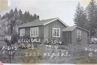
This house in the Wellsdale plat was built in 1935. The owner left the sides covered by tar paper only, to reduce the assessed value of the house for property taxes.
In the era of the economic crisis called the Great Depression of the 1930s many people in Wedgwood had large lots with outbuildings such as a chicken house and a woodshed, and space for a garden so that they could live more cheaply by growing some of their own food. In the 1930s people in the Wellsdale plat from NE 80th to 85th Streets, 40th to 45th Ave NE lived on lots averaging more than two acres in size (except Lot 1 which was 19 acres) and they lived a rural life.
Copyright notice: text and photos in this article are protected under a Creative Commons Copyright. Do not copy without permission.
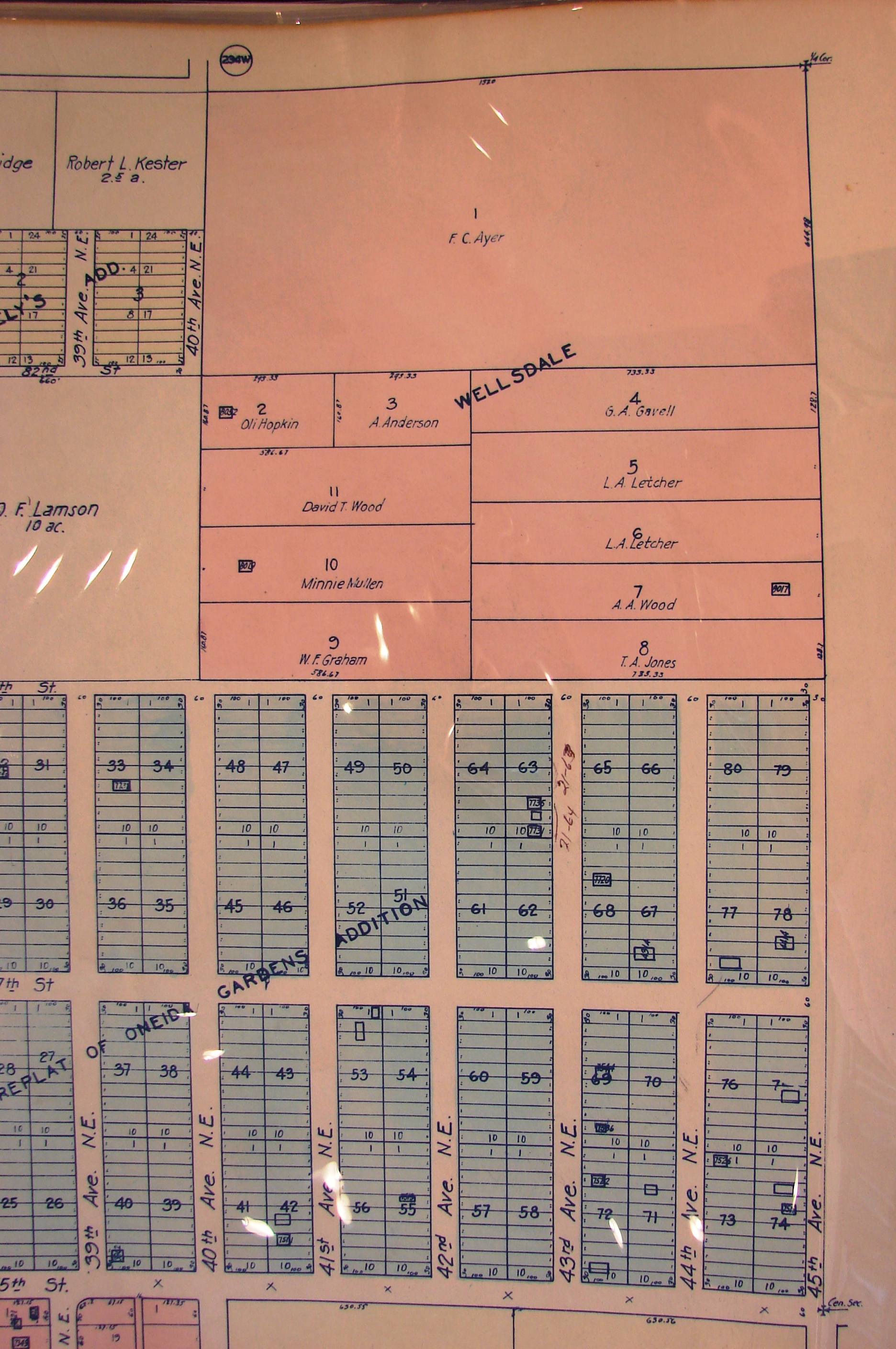
The Wellsdale plat (pink) had only eleven house lots marked, with no interior streets. Small black squares are locations of houses as of 1930. Just south of Wellsdale is today the site of Decatur & Thornton Creek Schools from NE 77th to 80th Streets, 40th to 43rd Avenues NE. Source: Kroll map of 1930.
Wellsdale plat
To “plat” an area means to mark out the streets and divide the land into lots for houses or commercial buildings. The Wellsdale plat, shown as the pink square in the photo at right, comprised a total of forty acres.
Wellsdale was unusual in that it was platted without any interior streets. Each Wellsdale lot, designated as Tracts 1 through 11, had access to one of the streets around the perimeter of the plat: NE 80th to 85th Streets, 40th to 45th Avenues NE.
The blue rectangles shown south of Wellsdale are part of the Oneida Gardens plat which was laid out in 1889. Block numbers 45 through 64 of Oneida Gardens, the three blue rectangles directly south of Wellsdale, are today the sites of Decatur School and Thornton Creek School.
What does the “Wellsdale” name mean?

Wellsdale School, Oregon, in the 1890s.
When a landowner files a plat with city or county government, the owner gives the plat a name but does not have to give an explanation for the name. The Wellsdale plat in Wedgwood was filed in 1902 by Gordon V. Skelton who lived in Corvallis, Oregon. We can guess that Skelton chose the name inspired by the “market town” of Wellsdale which was near Corvallis. That town of Wellsdale was on a railroad line and was a place where farmers brought their produce to be sold or distributed via the rail link.
In the early 1900s Wellsdale in Oregon was a transportation crossroads, a market town and had a post office, which is one marker of a “real” community, and there were enough families that a schoolhouse was in operation.
Did Gordon V. Skelton choose the name “Wellsdale” for his plat in Seattle because he hoped his Seattle property would, like Wellsdale in Oregon, become a vibrant community with a stop on a future railroad?
Gordon V. Skelton, owner and namer of the Wellsdale plat
Gordon V. Skelton was born in 1867 and grew up as the third of seven children on a farm in Arkansas. In 1895 at age 28 he obtained a position as professor of mathematics at what was then called the Agricultural College of the State of Oregon at Corvallis. The school had an experimental farm of 35 acres and part of faculty duties included supervision of the farm work. By 1900 there were about 400 students enrolled at the college and the population of the town of Corvallis was about 1,800. Corvallis had only unpaved roads, no streetlights, and had wooden sidewalks. There were no state highways, and just one train per day arrived and departed for Portland.
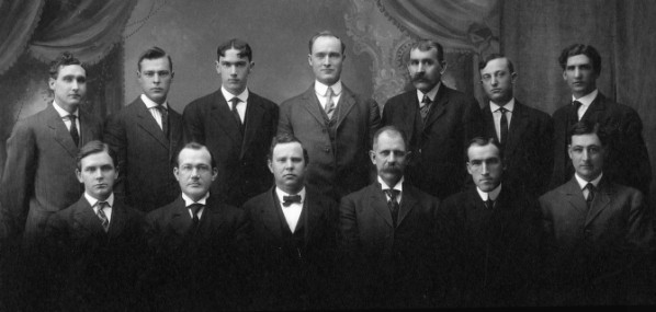
Gordon V. Skelton, wearing a bow tie in the front row, third from left, in 1909 with the faculty of the School of Engineering and Mechanic Arts, Oregon State University. Photo courtesy of Facilities Services Records, OSU Archives.
By the early 1900s Skelton’s title was Professor of Mathematics and Engineering, and later he became the head of the school’s Highway Engineering curriculum. His two sons both became civil engineers with the Oregon State Highway Department. Prof. Skelton’s 44-year career at Corvallis ended due to a heart attack at age 71, and he died a few months later in 1939.
Wellsdale, Oregon, passes out of existence
By the time of Prof. Skelton’s death in 1939 the town of Wellsdale, Oregon, no longer existed. Oregon’s State Highway Commission had been established in 1913 and development of a state highway system had taken the place of train service. Towns like Wellsdale which were bypassed by the highway, dwindled in population as trains stopped running and the train stations closed. Rural areas like Wellsdale had become completely transformed by the use of cars and trucks, and by highways instead of rail routes.
Wellsdale in Wedgwood becomes part of the City of Seattle
We can wonder whether, in 1902 when Prof. Skelton chose a plat name for his land in Seattle, he had the foresight to see that railroads were in decline and the development of a road system would be “the next thing.” Perhaps Prof. Skelton was a member of the Good Roads movement which began nationally in 1892; Oregon’s Good Roads Association was organized in 1902. If so, then we can wonder whether Prof. Skelton chose the name Wellsdale for his property in Seattle in 1902 because he hoped his plat would become a hub on a Good Road, rather than a railroad.

Forrest Goodwin, age 22, in a 1933 photo with the Northeast Transportation Company bus.
No railroads, street cars or state highways ever came to the Wedgwood neighborhood in Seattle, and the area remained so remote that in 1926 residents had to organize their own private bus service. The nearest elementary school was in Ravenna, so an independent school district was formed to build the Maple Leaf School on NE 100th Street. After the isolated, rural years of the 1930s some neighbors fought the process of bringing Wedgwood into the Seattle city limits in the 1940s and 1950s.
The national Good Roads movement of the 1890s was largely begun by bicyclists who could not ride because of the unsuitability of roads. Today throughout northeast Seattle, roads are in the process of being improved for safety including the sharing of the roads with bicycles.
Sources:

This Little Free Library in the Wellsdale plat is on 43rd Ave NE a few doors north of NE 80th Street.
Census and directory listings for Gordon V. Skelton.
“Death Ends Long Service,” Oregonian, October 17, 1939, page 8 (death notice for Gordon V. Skelton.)
Facilities Services Records of Oregon State University Archives, Corvallis, Oregon.
The Good Roads Movement in Oregon: 1900-1920. Thesis (1966) by Hugh Myron Hoyt, University of Oregon Libraries.
Kroll Map of 1930, Wellsdale and Oneida Garden plats in Wedgwood.
Plat maps: – King County Parcel Viewer — after entering an address and going to the “property detail” page, on the right margin is a link for the plat map of that area.
Puget Sound Regional Archives, Bellevue, WA. Property tax assessors books and house photos from property record cards for the Wellsdale plat.
Note on Wellsdale (also known as Wells) in Benton County, Oregon: the site became Camp Adair during World War Two and was used for troop training.
