
 In the Meadowbrook neighborhood of northeast Seattle, the North and South Forks of the Thornton Creek system come to a convergence point on 35th Ave NE at NE 107th Street. Since the 1990s intensive work has gone into this site, including the creation of Meadowbrook Pond to collect and filter the water before its final outflow into Lake Washington at Matthews Beach.
The Thornton Creek system with its many tributaries has always been integral to life in Meadowbrook. Meadowbrook’s earliest settlers took land claims where they would have access to creek water for irrigating crops, and where they would be able to dig wells to obtain fresh drinking water.
In the days of farming in Meadowbrook, different segments and tributaries of the creek were known by the name of the closest resident. By the 1890s the first land claimants, the Beckers, had sold some of their land but they still lived near what is now Lake City Way at NE 107th Street. The creek flowed past Beckers’ into the valley of the Fischer farm at the present site of the fields of Nathan Hale High School.
The Nishitani family with their plant nursery at 98th & Ravenna named their tributary Willow Creek for the tree on its banks. Farther to the east of 35th Ave NE, the converged main stream was known as Matthews since John Matthews owned land from NE 95th Street over to his home on the shore of Lake Washington.

Thornton Creek
In the 1990s activists such as Brian Bodenbach, one of the founders of the community group Thornton Creek Alliance, began to bring attention to the health of the creek as a wake-up call about pollution, flooding, and the need to promote clean water for the health of people, plants and animals.
Also in the 1990s government departments such as Seattle Engineering and Seattle Public Utilities worked to create Meadowbrook Pond, first created in 1998, and began to take an overall-view of the entire creek system along its eighteen-mile length.
At that time in the 1990s, the name Thornton Creek began to be better known, but why was this name chosen for the watershed system? Who was Thornton? To date, we have not found any evidence of who Thornton Creek was named for.
This blog article will tell about the life of John Thornton, an early settler in Washington Territory. Even though he never lived in the Seattle area, I speculate that the watershed system might have been an honorary name, because John Thornton served in the early legislature of Washington Territory.
In 1889, the year of statehood for Washington, property maps were drawn up to show the earliest original land claims by white settlers. The maps recorded the names of land purchasers or original homestead claimants even if, by 1889, that person no longer owned the land. An example is Charles Becker, whose name is written on the present site of Meadowbrook near the present site of Nathan Hale High School at 105th & 35th.

Thornton Creek today follows its same course but is an urban stream with houses built close by. Photo courtesy of Anna, 2022.
On the Township 26 map of north Seattle (shown below) the bottom line of the map is 85th Street. The vertical line farthest to the right is 35th Ave NE. At the intersection of NE 105th Street and 35th Ave NE the map shows the place where the South Fork of Thornton Creek crosses 35th Ave NE, flowing from west to east. The name of Charles Becker is written on the map at the site of today’s Meadowbrook field at Nathan Hale High School.
The certificate date written under under Becker’s name is September 22, 1880. This is not the exact date of his land acquisition but is the date that the certificate was issued. We know that not long after this map was made in 1889, August Fischer bought large portions of Becker’s land.
On the Township 26 map shown below, the small lake with the name John Welch marked, is today’s Haller Lake at the intersection of N. 125th Street and Meridian Ave N. near Northwest Hospital. North of that, following the creek line of the North Fork, we see that the mapmaker has written the name Thornton Creek. I theorize that the mapmaker of 1889 in the Surveyor General’s Office in Olympia, chose that designation to honor John Thornton.
At the end of this article, after the source list, is a current map of the Thornton Creek Watershed.

Township 26 in Seattle. The bottom line is 85th Street and the top line is 205th which today is the county line between King and Snohomish counties.
Who was John Thornton?
Unlike a homestead claim which required living on-site, John Thornton purchased some King County land in cash at the Olympia land office. It is possible that like many people in that era, Thornton was making speculative purchases of land which might increase in value as Washington Territory grew. Among several land purchases, he owned some land in eastern King County near today’s Duvall.
The 1870s and 1880s was a time when it was anticipated that railroads would build lines to Seattle, so some people bought land in hopes of its future use or value if a railroad came through. An example of this is Marshall Blinn, whose name can be seen in several places on the Township 26 map, with certificate dates of 1870 and 1871. One of the sites is in the lower right corner, at the intersection of 85th & 35th where today there is a Rite-Aid in the Wedgwood neighborhood.
Marshall Blinn was the founder of the sawmill town of Seabeck on Hood Canal, Kitsap County. Blinn made so much money from the lumber business that he retired in 1867 at age 40, and moved to Olympia. From then on Blinn invested money in various pursuits, including mining, cattle ranching and politics.
One of the earliest settlements in western Washington Territory was Dungeness, just west of Port Townsend along the Strait of Juan de Fuca. The area is a rich valley watered by the Dungeness River, flowing out from the Olympic Mountains. On the census of 1850 in Washington Territory, John Thornton, age 25 and born in Indiana, is shown already living in Dungeness.
Thornton was not in the first group of white settlers who arrived via ship from San Francisco, some of whom had just come from the California Gold Rush of 1849. Thornton came shortly thereafter, and his early arrival is also indicated by the site of his land claim: he got one of the best sites, with frontage on Dungeness Bay.
When government land surveyors marked out the Dungeness area in 1859, they showed the names of the settlers who were already living there. John Thornton’s land claims included the Section squares marked 26 and 35 on the Dungeness survey map of 1859. Part of Section 26 is in the water of Dungeness Bay, so the number 26 is seen above the shoreline and John Thornton’s name is written below it.
In the 1890s John Thornton told his story for the Clallam County historical records. (See: Dungeness: The Lure of a River in source list.) Thornton journeyed across the USA on a wagon train and came to Steilacoom in 1850, which was then the largest settlement on Puget Sound, founded by Capt. Lafayette Balch. (Capt. Balch was the great-great-uncle of Albert Balch, builder and “town founder” of the Wedgwood neighborhood.)
John Thornton’s adventures in 1851
John Thornton joined in with some other men in September 1851 on an excursion to hunt for gold on Queen Charlotte’s Island near Vancouver Island, Canada. The group was taken prisoner by Indians and held for 54 days. They were able to send a letter out with a friendly Indian, to Capt. Lafayette Balch. Capt. Balch sailed a schooner to Olympia where he was given authority to make a rescue, taking soldiers with him. Balch Island near Queen Charlotte was named for this adventure. The group was safely ransomed and returned, and John Thornton then went back home to Dungeness; perhaps he had had enough of adventuring.

Survey of 1859 map, Dungeness, Clallam County. Bureau of Land Management survey records, Washington and Oregon.
The Dungeness Valley soil was rich and in addition to cutting and selling timber for income, Thornton and other settlers planted potatoes.
One of theDungeness settlers went to San Francisco to obtain a team of oxen, and brought them back by ship. Then Thornton and his neighbors began plowing with the oxen and they planted wheat. Ships came into Dungeness Harbor to load timber bound for San Francisco, and the settlers could also market their crops in Victoria.
John Thornton stayed in the Dungeness and Port Townsend regions the rest of his life, and he lived a long life, dying in February 1904 at age 78. These are indicators that his Dungeness farming business was successful and he was able to support himself, perhaps even with a little extra money to invest in land speculation.
John Thornton starts a family
Another measure of Thornton’s success was that he was able to marry a widow, Sarah Pilcher, and incorporate her children into his household. This shows that John Thornton had enough money to support a family. At the time of their marriage in 1868, John was 43, Sarah was 41, and her five children ranged in age from 18 to 6. The three youngest were born in California so this tells us that the Pilcher family did not come to Washington Territory until at least 1862.
John Thornton’s 1868 marriage tells us that he was prosperous enough to support a family, and it also tells us something about his character. In early Washington Territory there were very few white women, and there was a high number of single men. As a widow who wanted to remarry, Sarah Pilcher would have had a wide selection of men to choose from! She chose a man who would accept her children from her previous marriage, and who had the means to support them. Since Sarah agreed to marry John Thornton, she must have considered him to be kind, steady, economically successful and not given to excessive drinking or abusive behavior. He was willing to take in and support her children, though it may be also that there was an advantage to him in having Sarah’s two oldest sons to help with work on Thornton’s farm.
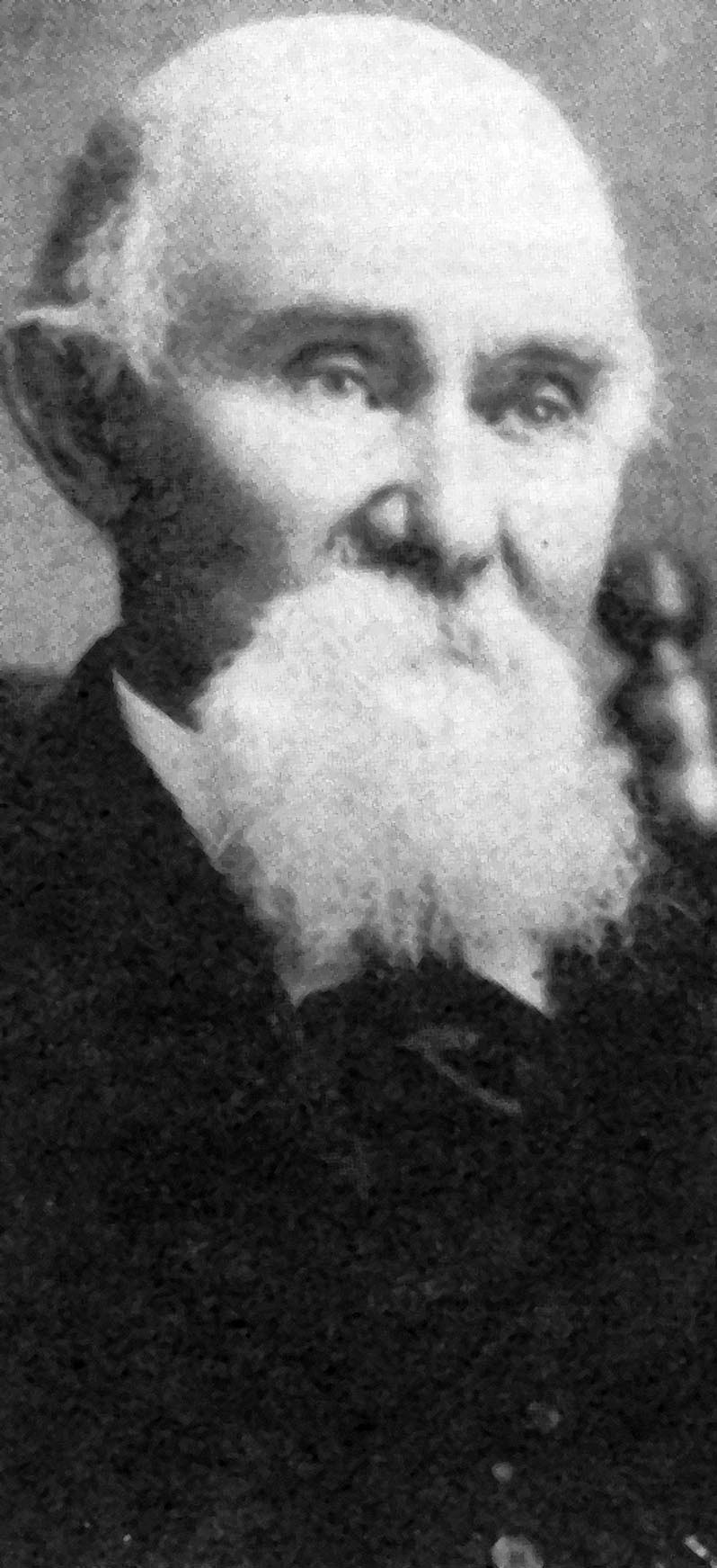
Undated photo of John Thornton, courtesy of Clallam County Historical Society.
On the census of 1880 a total of eleven people are shown living in the Thornton household. Sarah’s youngest child from her first marriage, Harry, now age 19, was at home as well as three daughters, ages 8 to 11, born to John and Sarah. The local schoolteacher, Harriet Cooper, was boarding at the Thornton house and there were two school-age girls who appear to be boarding as well, perhaps so that they could attend school.
One member of the household, Rebecca McKessick, age 15, was listed as “ward” of the Thornton family. The census listing tells that Rebecca was born in Clallam County of an Irish immigrant father and Native American mother. The McKessick family was listed on the 1870 census but by 1880 something must have happened to the parents, as Rebecca and her two brothers were each wards with different families in the community.
Running such a large household in 1880 implies that John Thornton’s wife Sarah was a good manager and the family was interested in being involved in community life, as shown by their support of the school. The school, called Thornton Lane School, was on land that they donated.
John and Sarah Thornton were still together after thirty-five years of marriage, at the time of John’s death in 1904 at age 78. He had listed himself on the census of 1900 as a retired farmer, and the Thorntons had moved from their farm to live in Port Townsend. Another measure of John and Sarah’s long and happy lives together is that the Thornton and Pilcher children were listed on the census as continuing to live in and around the Dungeness/Port Townsend areas, showing close family relationships. Sarah Thornton died in 1915 at age 88, and the Thorntons are buried in Laurel Grove Cemetery in Port Townsend.
Why did John Thornton buy land in King County?
We can speculate on the reasons why, at age 60 in 1885, John Thornton chose to buy land in King County which he didn’t intend to live on himself. The land was in eastern King County near the present Duvall area. Thornton may have been investing/speculating on a possible increase in the value of the land, especially if a railroad might choose a route through there. Perhaps he bought the land intending to make a gift of it to one of his children.
Clallam County historical records show that from 1878 to 1886 John Thornton served as county treasurer (see: History of Clallam County in source list.) This was not a full-time paid position, but as treasurer Thornton made periodic trips to Olympia in an official capacity for meetings at the territorial legislature. His purchase of property in King County was made in-person at the Olympia land office in 1885. (See: land claim info in source list at the end of this article.)

Thornton Creek makes its way toward its outlet at Matthews Beach on Lake Washington. Photo courtesy of Anna, 2022.
It is possible that John Thornton never saw his land in eastern King County – it would have been very difficult to get to in those days, as there was no road to the site. There’s no record of whether he “explored” around in King County or other parts of Washington Territory; we might assume that he was too busy with his farm in the Dungeness area. There is no record of him doing anything in the north Seattle area where Thornton Creek is located, so we still don’t know if the creek was an honorary name or if it refers to some other person.
When we think of John Thornton, possibly the namesake of Thornton Creek or possibly not, we recall him as one of the pioneer success stories of early Washington days, a man who had a long and well-lived life.
Source list
A Small World of Our Own: Authentic Pioneer Stories of the Pacific Northwest from the Old Settlers Contest of 1892. Pages 97-100 by Hugh Crockett, one of the rescue party of the men taken captive along with John Thornton, on the Queen Charlotte’s Island. This book is an anthology collected by Rev. Myron Eells, for a contest sponsored by a Tacoma newspaper. The stories are in the scrapbooks of Rev. Eells now housed at Whitman College’s Penrose Memorial Library. This edition published 1985, 979.5Br39 at Seattle Public Library.
Bureau of Land Management and Land Status/Cadastral Records of Washington and Oregon. John Thornton claim in Clallam County: 31N, 4W, Sections 26 and 35, WAOAA 097489, certificate date 7/8/1874. Claim in King County: 26N, 7E, Section 18, WAOAA 062792, certificate date 10/1/1885. For the writing of this blog article I contacted the regional office of the Bureau of Land Management to ask about John Thornton’s land certificate. The purchase records show that he paid cash ($1.25 per acre) at the land office at Olympia.
Dungeness: The Lure of a River, Sequim Bicentennial Committee, 1976. 979.711 Se64D, Seattle Public Library/Central.
Federal Census of years 1850 to 1900, accessed on-line via the Seattle Public Library.
HistoryLink essays on the formation of Clallam County; Jefferson County; history of Sequim and the Dungeness Valley: Essays # 7472, 7576, 8555.
Jimmy Come Lately, History of Clallam County, edited by Jervis Russell, 1971. 979.7111 R914J, 9th floor reference collection, Seattle Public Library/Central. (Note: Jimmy-come-lately is the name of a creek on the property of Jimmy Whitcomb, another pioneer resident.)
List of representatives in the early years of the state legislature (Washington Territory): http://leg.wa.gov/History/Territorial/Documents/territorial_assembly_members.pdf
Property records — Puget Sound Regional Archives, original lists of property owners up to the year 1889.
Township Plats of King County, Washington Territory. Township 26, 1889. Seattle Room maps, Seattle Public Library, R912.797K589A
Washington Digital Archives, dates of birth/death/marriage.

Current map of the Thornton Creek Watershed
